
This page introduces the Via Claudia Augusta cycling route with a profile and a selection of pictures. Experience the Germans’ second most popular international cycling route during a day trip or on a long-distance tour over several days. The Via Claudia Augusta is considered the easiest way to cross the Alps on a touring bike. To make it even easier, you can take advantage of the bicycle shuttles that will carry you up any or all of the passes en route. It is an adventure most people can manage. Cyclists from all continents and of all ages between 5 and 93 have jumped at the opportunity to embark on this unique tour.

Are you already familiar with the new Whatsapp function, channels, through which subscribers can follow information? For reasons that we have not yet been able to find out, our “Travel Channel Via Claudia Augusta” cannot yet be found via the search function in Whatsapp, which you can access via “News” and then with the “Plus”. However, if you open this page on your smartphone, you can click on this link and follow the channel. In this way, we can inform you in the preparation phase of your discovery of the Via Claudia Augusta, during the discovery and also afterwards about news and interesting facts, e.g. if a route of the Via Claudia Augusta is interrupted in an area and a detour is necessary or if the bike shuttle is delayed ...
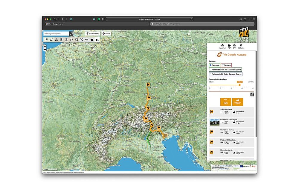
With the interactive map you can plan your trip. You can transfer this planning by QR code or conventional code to the apps for iPhone and Android. On the internet portal www.vicalaudia.org and in the interactive map you can also have a good smolder and get in the mood for the trip. > to the interacitve map
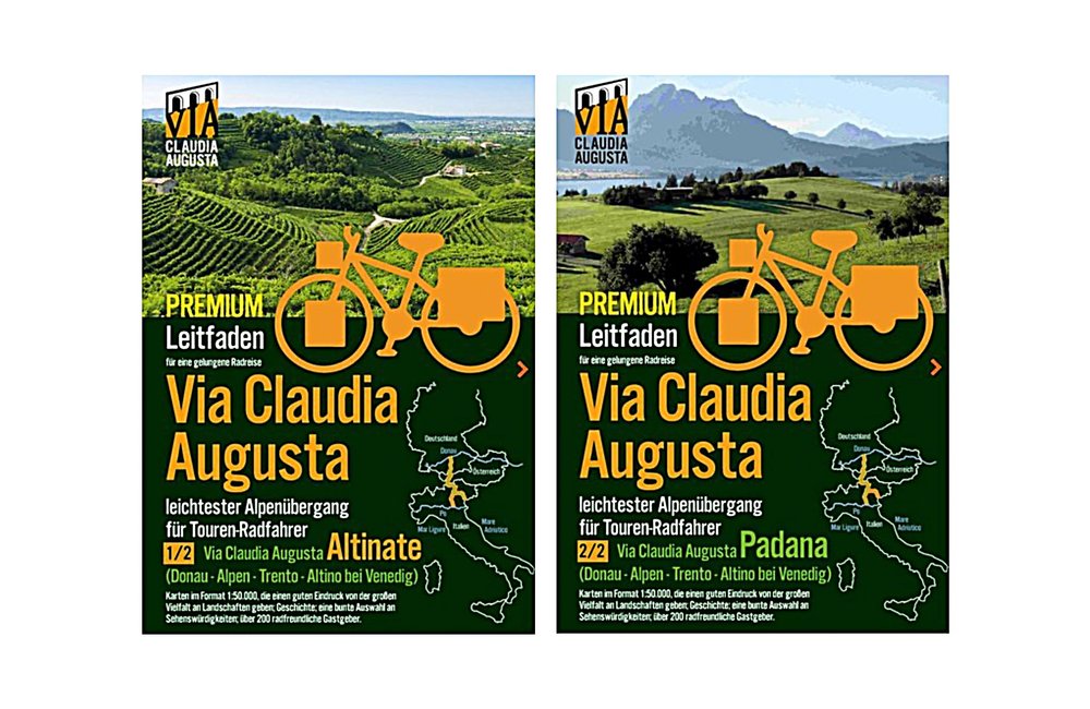
For those who love to have something tangible in their hands or would like to have a printed guide in addition, there are 2 cycling guides. One covers the Via Claudia Augusta from the Danube to Altino (near Venice) and the other from the Danube via Verona to Ostiglia on the Po River. The premium version of the cycling guides has a practical spiral binding. You can also download the map sheets for free here (Altinate) here (Padana) downloaden, so you can leave your guide protected in your luggage and also make notes in the map without writing in the guide itself. If you print the maps in A4 they are also bigger.
When Emperor Claudius ordered that the Via Claudia Augusta be expanded, he created the first road that connected Europe: from the Adriatic seaport of Altinum and Ostiglia on the Po all the way to the Danube. Along the Via Claudia Augusta cycling route, the ancient culture and trade road of the Roman Empire comes back to life. It is incredibly diverse: three countries, the Alps, ten regions, and three climate zones stretching from the north to the south of Europe offer a magnificent range of landscapes . Cyclists get to marvel at a new landscape every twenty or thirty kilometers. In late April and early May, you might even experience three seasons during a single cycling tour: bike along a late, snow-covered field on a shady part of the Fernpass, sunbathe by the Adriatic Sea, and take in all facets of spring in between. Apart from this cornucopia of landscapes, you will encounter lively towns, pretty villages, hundreds of historical sites, welcoming people and their fascinating cultures. Plenty of culinary delicacies and refreshments will keep your batteries charged. Some restaurants and inns along the way even serve dishes that may already have been popular during Roman times. Autumn is a particularly rewarding time for foodies. It offers the full breadth of products grown in the various regions. Enjoy the easiest way to cross the Alps by bike
2 versions: in Trento, the road forks. The Via Claudia Augusta ‘Altinate’ branch runs to Feltre and terminates in Altino near Venice; the Via Claudia Augusta ‘Padana’ branch runs to Verona and terminates in Ostiglia on the Po river.
Route: approximately 700 km from Donauwörth on the Bavarian Danube across the Alps to Altino near Venice or 650 km from Donauwörth to Ostiglia on the Po river.
Traffic connections: the railway stations of Donauwörth, Augsburg, Landeck, Bolzano/Bozen, Trento, Venice-Mestre, Rovereto, Verona and Ostiglia are perfectly connected to the international train network; public transport runs parallel to the majority of the route; optimally connected to the European long-distance cycling route network
Free parking in Donauwörth for the duration of your cycling tour
Logistical support: bike shuttle across all passes; shuttle service to take you back from Italy to Germany on six days of the week (avoiding high traffic volumes on Saturdays)
Route profile: on almost completely tarmacked cycling paths and quiet secondary roads; highest points: Fernpass (about 250 meters above Biberwier), Reschenpass (about 500 meters above Pfunds); cycling shuttles are available to take you up the passes, leaving only very few inclines for you to scale on your own.
Signage: mostly signposted, but we recommend taking a guidebook and/or GPS device
Travel resources: printed guidebooks, an interactive map for your individual travel planning needs available on this page, apps helping you navigate your individually planned route and offering information on all sights
Awards: representative surveys have shown that the Via Claudia Augusta cycling route is the second most popular international cycling route among Germans; 4 stars from the Allgemeiner Deutscher Fahrrad-Club (ADFC); every year, around 40,000 cyclists from all continents and aged 5 to 93 years choose the route

Elevation profile of the Via Claudia Augusta ‘Altinate’:: Danube - Trento - Feltre - Altino near Venice
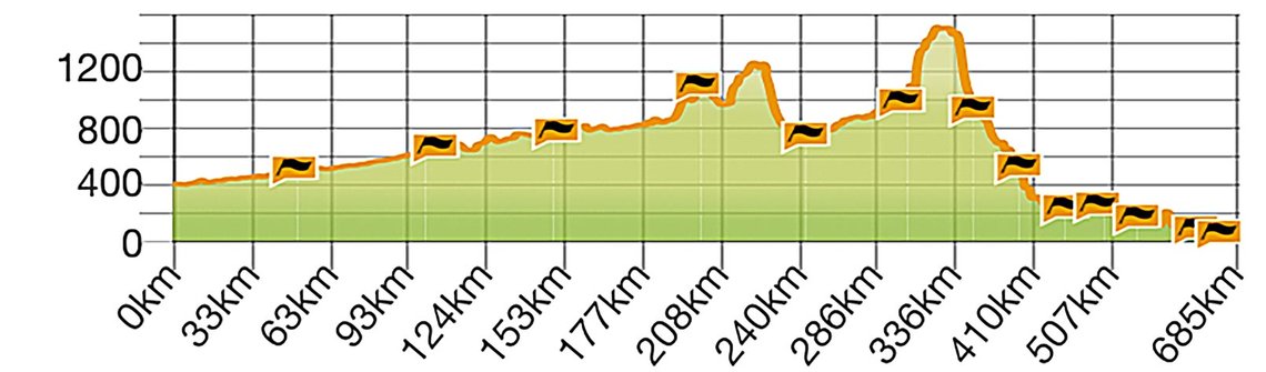
Elevation profile of the Via Claudia Augusta ‘Padana’: Danube - Trento - Verona - Ostiglia on the Po river.


On this map, the historical route, the cycling route and all other content have been pre-selected. You can see all pre-selected content by zooming in on the map. To browse a full-screen map and/or plan your trip on the full screen, click the orange bar underneath this text.