Where the Inn and Via Claudia Augusta describe a corner around Land-eck, there lies TirolWest, Tyrol's region of enjoyment. Where the Inn Valley and the Stanzer Valley towards Arlberg meet between high mountain walls, people have been meeting for thousands of years. The offer is accordingly varied: mountain nature, ancient history, culinary delights, lively culture, ...


Unlimited skiing pleasure and the best piste conditions await you when skiing in the numerous ski areas in and around the Tirol West holiday region - the Venet, Ischgl, St. Anton am Arlberg, Serfaus-Fiss-Ladis, ... pleasure ski areas are waiting to be conquered by you. Off-piste you can also make the most of your time: tobogganing, cross-country skiing through winter landscapes covered in deep snow, romantic winter hiking trails or touring amidst the mountain giants. And all this combined with culture, history and culinary delights.


Text of the historical maps of ...
before the year 0
Early densely populated
Already in early history, the area around Landeck was relatively densely populated. Above Schönwies, in Stanz and Grins, in Perjen, in Fließ, at the entrance to the Kaunertal, in Fiss and Serfaus, ... - on every sunny slope and every high terrace settlements are proven or at least there are indications of settlement. The settlements were connected by cart paths. In addition to one in the Inn valley, there was also a shortcut from the Kaunertal valley over the Piller Sattel to Imst. Above Fliess was a burnt offering site where gods were invoked for centuries, until Roman times. In the archaeological museum of Fliess you can marvel at early historical finds from this time, which you can otherwise only find in such abundance and quality in large cities.
450
early Christian churches
In the Landeck area the Via Claudia Augusta largely ran along the slope – the section between the Inn bridge near Starkenbach and Landeck followed the striking and picturesque route over the “Platte” to Fließ, where ruts in the rock dating from different periods tell stories about the road. The Via Claudia Augusta only left the slope in the vicinity of Landeck Castle – presumably because there was a road station there and the road branched off over the Arlberg. The important transport connection not only brought economic development but also a lively cultural exchange that is reflected among other things in the area’s early Christianisation. The parish church in Landeck and St. Lawrence’s Church on the hill above Imst have their roots in the fififth century, while the ‘Maaßkirche’ church next to the archaeological museum in Fließ dates back to the sixth century.
1787
Landeck as a transport hub
Two long-distance roads already converged for the first time back in Roman times at the confluence of the Sanna and the Inn. In 1787 the road to Vorarlberg, that had for a long time no longer been navigable, was renewed and restored to new life and the valley basin finally became a transport hub. The rest was done by the construction of the Arlberg railway in 1884, during which 800 jobs were also created and the population grew rapidly. Around 1900, the municipalities of Perfuchs and Angedair were merged into Landeck, that gained market rights in 1904 and became a town in 1923. Landeck had already been a municipal centre since 1868 when there was not yet even a place called Landeck but only the castle. The loser of the shift of the east-west traffic corridor to the Arlberg route was incidentally Zwischentoren, between Fernstein and Reutte. Many of the bitterly poor people of Ausserfern consequently became migrant workers in the more prosperous neighbouring regions to the north.
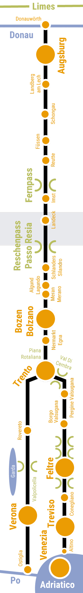
Basically, the Romans looked for the shortest route for the Via Claudia Augusta. The Roman road therefore ran as straight as possible, usually on the sunny side of the valley, slightly above the valley floor, so that it was not affected by storms and was quickly dry and snow-free again after rain and snowfall. Of course there are exceptions to all rules.
In this map you can see what there is to discover in the region.
In this map we show you how to cycle the Via Claudia Augusta north and south from the region.
In this map we show you how to walk the Via Claudia Augusta from north and from south of the region.
In this map we show you how to get from the region by car, camper and bus, ... the Via Claudia Augusta and its sights to the north and south.
Information on the entire Via Claudia Augusta can be obtained from
Via Claudia Augusta Info
www.viaclaudia.org
info@viaclaudia.org
0043 664 27 63 555
Detailed questions about the region are best answered by
Tourist information from TirolWest
www.tirolwest.at
Main square 6, 6511 Zams
info@tirolwest.at
0043 5442 65600
In this map, we show you the hosts in the region along ghe Via Claudia Augusta.


