detailed route description of the ‘Altinate’ cycling route (from Trento to Altino near Venice)

Feltre Piazza Maggiore Rad Bici

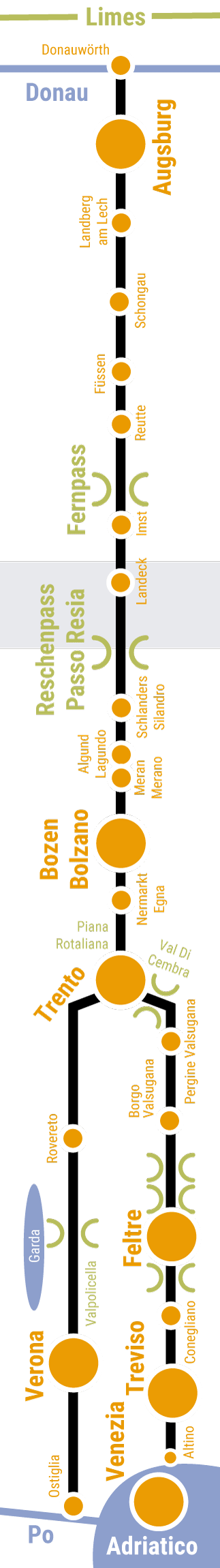
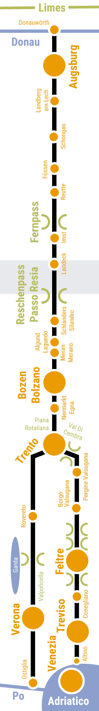
The content menu at the start of the route description allows you to jump directly to the various sub-sections. You can also use the navigation elements at the end of each section to switch between the two variations of the cycling route, ‘Altinate’ and ‘Padana’. You can use the detailed route description for referenceduring your cycling tour alongside the cycling maps available for download here. Alternatively, you can download offline navigation apps for your iPhone or Android or simply take a printed guidebook with you.


Jump to a specific section

BAVARIA

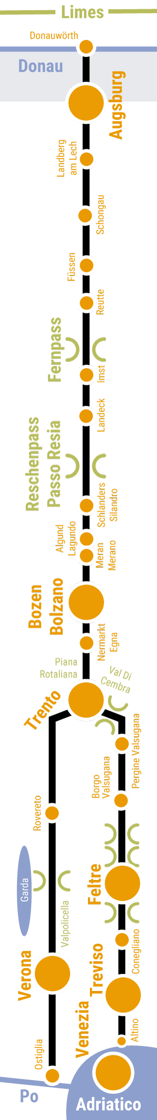
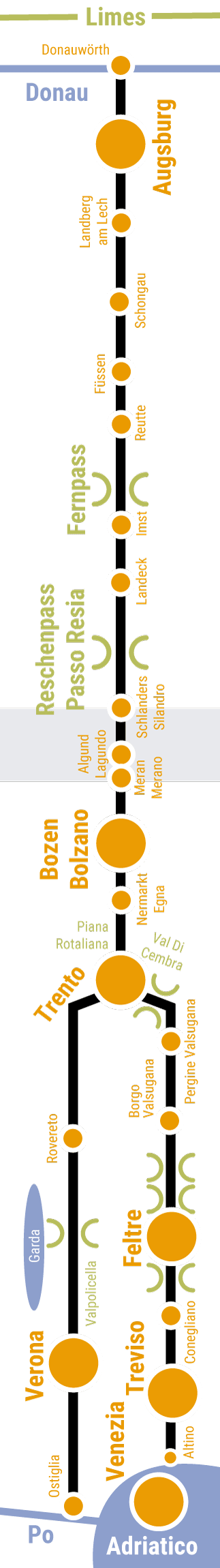
01 ... Donauwörth and Donau-Ries

02 ... Between Donauwörth and Augsburg

03 ... Augsburg

04 ... Between Augsburg and Landsberg am Lech

05 ... Landsberg am Lech

06 ... Between Landsberg am Lech and Schongau

07 ... Altenstadt, Schongau and Peiting

08 ... Between Schongau and Füssen

09 ... Füssen and Schwangau

TYROL

10 ... Between Füssen and Reutte

11 ... Breitenwang, Reutte and Ehrenberg

12 ... Heiterwang and Bichlbach

13 ... Lermoos, Ehrwald and Biberwier

14 ... Across the Fernpass

15 ... Between the Fernpass and Imst

16 ... Imst

17 ... Between Imst and Landeck

18 ... Zams, Landeck and Fließ

19 ... Between Landeck and the Reschenpass

Reschenpass > Trento (South Tyrol, TRENTINO)

20 ... The Reschenpass

21 ... The Upper Vinschgau valley

22 ... Laas/Lasa und Schlanders/Silandro

23 ... Goldrain/Coldrano, Latsch/Laces und Kastelbell/Castelbello

24 ... The Lower Vinschgau valley

25 ... Algund/Lagundo, Meran/Merano and Marling/Marlengo

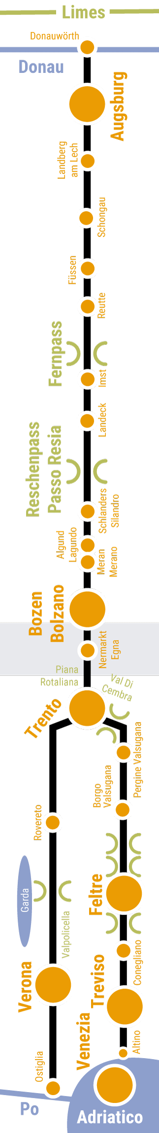
26 ... Between Meran/Merano and Bolzano/Bozen

27 ... Bolzano/Bozen

28 ... Bolzano/Bozen and Environs

29 ... Across the Piana Rotaliana

30 ... Val di Cembra, Pinè

empty ... Trento > Altino/Venice (TRENTINO, VENETO)

31a ... Trento (towards Feltre, Treviso, Altino, Venice)

32a ... The upper Valsugana

33a ... The middle Valsugana

34a ... Tesino plateau, Lamon, Sovramonte

35a ... Feltre and the Feltrino area

36a ... The Valbelluna

37a ... The Altamarca

38a ... The right bank of the Piave river

39a ... Treviso

40a ... Silea, Roncade, Quarto D'Altino

41a ... The Lagoon


... Use the main menu on the website to jump to the subsections from Trento to the Po river via Verona (Via Claudia Augusta ‘Padana’).

DRUCK
Donauspitz, Mündung, Wörnitz, in die Donau, Donauwörth, Via Claudia Augusta, Bayern, Foto Donauwörth
Der Frühling in Donauwörth
Foto von einer Staudammmauer in Donauwörth
Reichsstraße in Donauwörth, Foto von Lois Lammerhuber
Donauwörth, Frühling, Zusammenfluss
Luftbild von Goldberg in Donau Ries
Dorf mit Burg in Huisheim, Donau Ries
Foto von Radfahrern in Donau Ries

Arrival recommendation

Bahnhofsplatz in Donauwörth, Foto von Colin Smith

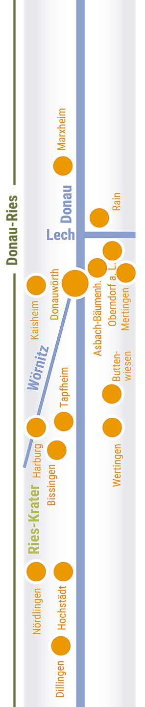
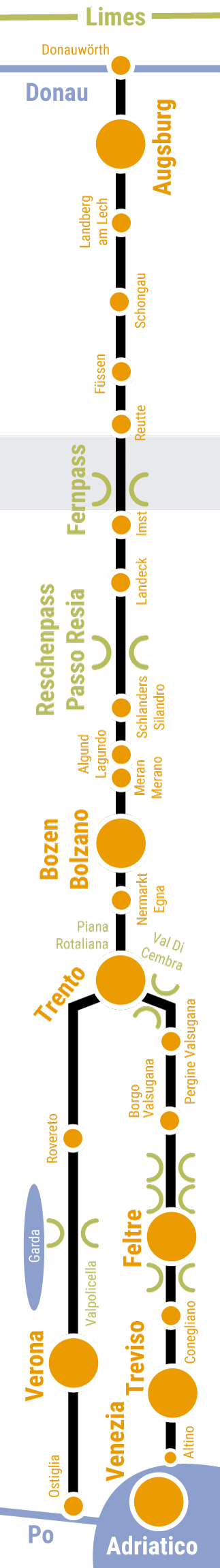
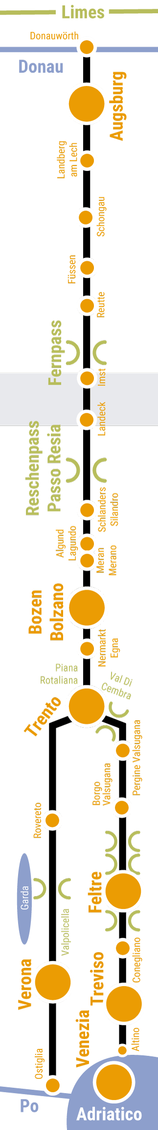
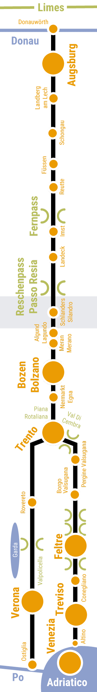
We recommend that you cycle to Donauwörth, which is well connected to the international network of cycling paths. Alternatively, take a train to the Donauwörth intercity railway station. If you are arriving by car, you can leave your car at the parking lot on Neue Obermayerstraße while you explore the area by bike. Consider arriving a day early so that you can start your cycling tour well rested and see a little of this lovely town before you set out. If you are missing any bicycle equipment, there are two well-stocked specialist shops in town: Uhl and Brachem.

Cycling route in Donauwörth

Radroute, historische interaktive Karte mit Symbolen

From the railway station, the route takes you across the island of Ried, where the first settlements of Donauwörth were established. You then reach the modern town center with the beautiful Reichsstraße street. Drop into the tourist information office if you still need any guides, maps or other paperwork, then continue across the Danube and southwards.

Returning to Donauwörth after your cycling tour

Zion Bus

To head back to Donauwörth after your tour, you can take the cycle shuttle. Bookings are available at www.viaclaudia.org. Link

Food and drink

Questions and information about the section

Information is available from

Via Claudia Augusta Info
www.viaclaudia.org/en
info@viaclaudia.org
0043 664 27 63 555

If you have specific questions about the town of Donauwörth, in particular, contact the

municipal tourist information office of Donauwörth
https://www.donauwoerth.de/tourismus/
Rathausgasse 1
tourist-info@donauwoerth.de
0049 906 78 91 51

For specific questions about the region, contact

the Donau-Ries tourist board
www.ferienland-donau-ries.de
info@ferienland-donau-ries.de
0049 906 74 211

Accommodation and camping

Radroute, Gastgeber, historische interaktive Karte mit Symbolen


Diesen interaktiven Bereich können Sie nutzen unter:
/en/road-biking/detailed-description-of-the-altinate-route

Do you have feedback or ideas for the cycling route? Let us know /


Diesen interaktiven Bereich können Sie nutzen unter:
/en/road-biking/detailed-description-of-the-altinate-route

jump back to the beginning of the detailed description of the Altinate cycling route / jump to northern Tyrol / jump to the Reschenpass / jump to Trento / jump to the whole history of the Via Claudia Augusta / jump to the history of the regions and towns along the Altinate route / jump to the ‘twenty-four maps through the centuries’ for each region along the Via Claudia Augusta / jump to the full spectrum of culture across the regions and towns (Altinate) / jump to the specialities of the regions and towns / jump to the wines of the regions and towns /


DRUCK
Radstaffel Übergabe
Ehemaliger Standort Submuntorium Burghöfe Druisheim Mertingen Lechtal, Foto Deininger
Kloster Holzen Allmannshofen im Lechtal, Foto Kloster Holzen Hotel GmbH
Merkurheiligtum Gersthofen Lechtal, Foto Deibler
Merkurheiligtum mit Leuten Gersthofen Lechtal, Foto Deibler
Ballonmuseum Gersthofen Lechtal, Foto Gersthofen
Bürger von Meitingen

Cycling route from the Danube to Augsburg

Radroute, historische interaktive Karte mit Symbolen

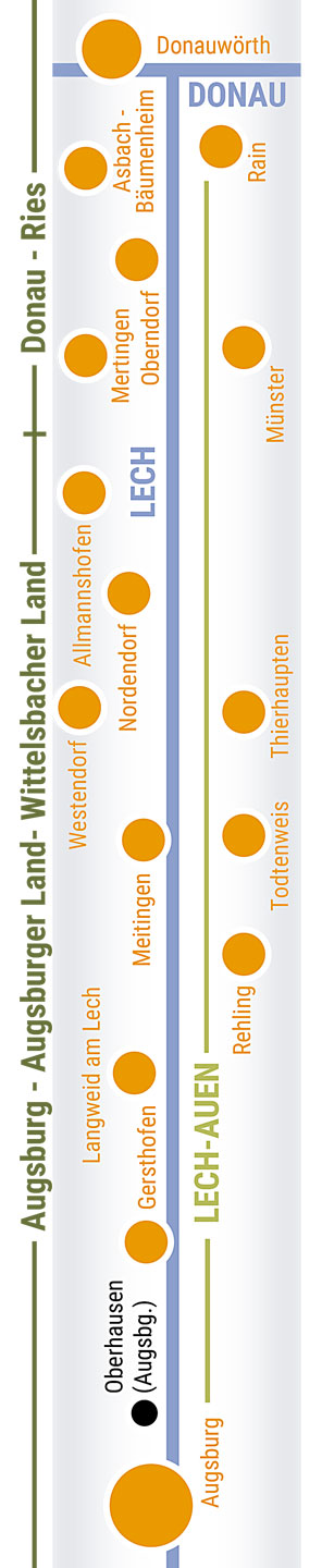
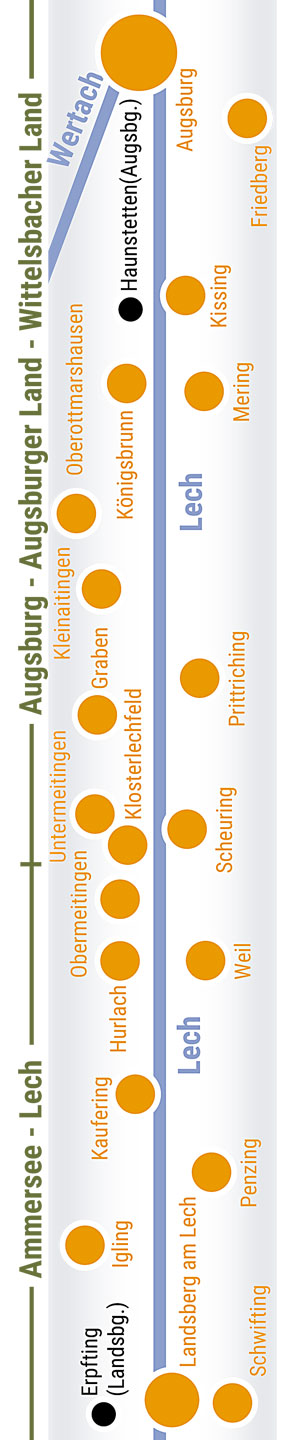
Before you really get going, consider taking a little detour to see the confluence of the Zusam and Danube. This used to be the end point of the old Roman road. Today, a reproduction of an ancient milestone reminds passers-by of this significant spot. Afterwards, the cycling route takes you southwards through meadows, fields and pretty villages. Between Mertingen and Druisheim, you will find a notice board telling you about Submuntorium, the Roman fortress which used to stand here. In Ostendorf, the route crosses the Lech river to guide you through the floodplains of the Lech. The section between Stettenhofen and Gersthofen largely follows the original route of the Roman road along the left side of the river. It then continues towards Augsburg along the right-hand riverbank.

Questions and information about the section

Accommodation and camping

Radroute, Gastgeber, historische interaktive Karte mit Symbolen


Diesen interaktiven Bereich können Sie nutzen unter:
/en/road-biking/detailed-description-of-the-altinate-route

Do you have feedback or ideas for the cycling route? Let us know /


Diesen interaktiven Bereich können Sie nutzen unter:
/en/road-biking/detailed-description-of-the-altinate-route

jump back to the beginning of the detailed description of the Altinate cycling route / jump to northern Tyrol / jump to the Reschenpass / jump to Trento / jump to the whole history of the Via Claudia Augusta / jump to the history of the regions and towns along the Altinate route / jump to the ‘twenty-four maps through the centuries’ for each region along the Via Claudia Augusta / jump to the full spectrum of culture across the regions and towns (Altinate) / jump to the specialities of the regions and towns / jump to the wines of the regions and towns /


DRUCK
Augsburg bei Nacht, Maxstraße, Foto Regio Augsburg
Augsburg Goldener Saal im Rathaus, Foto Regio Augsburg
Römermauer in Augsburg, archäologische Nischen, Dom, Foto Regio Augsburg
Augsburg Rathausplatz, Foto Regio Augsburg, Christine Pemsl
Radfahrer in der Fuggerei, Foto Regio Augsburg
Augsburg im 14. Jhd

Cycling route through Augsburg

Radroute, historische interaktive Karte mit Symbolen

In Augsburg, you can either follow the Lech or cross the MAN bridge in the north to take in the city itself. Augsburg used to be the provincial capital during Roman times and the home of the rich and influential Fugger family. Much of the route across the city follows the original Roman road: it leads past the Cathedral of Augsburg (which has a corner dedicated to local archaeological findings), across the Rathausplatz square with the Augustusbrunnen (a 16th-century fountain with a statue of Emperor Augustus), and the grand Maximilianstraße boulevard with its two fountains depicting Mercury and Hercules, respectively. The Basilica of SS. Ulrich and Afra and the Fugger houses are also situated on Maximilianstraße. Continue little further to the east and you will see the Fuggerei, the world’s first social housing complex. The route now takes you past the botanics and back to the Lech river, where its two branches reunite. Head south through the Siebentischwald forest.

Questions and information about the section

Accommodation and camping

Radroute, Gastgeber, historische interaktive Karte mit Symbolen


Diesen interaktiven Bereich können Sie nutzen unter:
/en/road-biking/detailed-description-of-the-altinate-route

Do you have feedback or ideas for the cycling route? Let us know /


Diesen interaktiven Bereich können Sie nutzen unter:
/en/road-biking/detailed-description-of-the-altinate-route

jump back to the beginning of the detailed description of the Altinate cycling route / jump to northern Tyrol / jump to the Reschenpass / jump to Trento / jump to the whole history of the Via Claudia Augusta / jump to the history of the regions and towns along the Altinate route / jump to the ‘twenty-four maps through the centuries’ for each region along the Via Claudia Augusta / jump to the full spectrum of culture across the regions and towns (Altinate) / jump to the specialities of the regions and towns / jump to the wines of the regions and towns /


DRUCK
Mercateum Königsbrunn Lechfeld Augsburger Land, Foto Königsbrunn
Mythräeum Heiligtum Lechfeld Augsburger Land, Foto Tschaikner
Historsche Radlergruppe Igling Ammersee, Foto Tschaikner
Schloss Igling Landkreis Landsberg, Foto Tschaikner

Cycling route through Augsburg’s Lechfeld towards Landsberg am Lech

Radroute, historische interaktive Karte mit Symbolen

From Augsburg, the route takes you through the Siebentischwald forest to Königsbrunn, where the famous Battle of Lechfeld took place in 910. Visit the Mercateum to see the Tabula Peutingeriana, a Roman street map, then head to the Temple of Mithras in the cemetery. Leaving the city, you will cross the highway before following one of the longest sections of the perfectly straight, original route of the Roman road. Cycle through meadows, fields and pretty villages towards Landsberg am Lech.

Questions and information about the section

Accommodation and camping

Radroute, Gastgeber, historische interaktive Karte mit Symbolen


Diesen interaktiven Bereich können Sie nutzen unter:
/en/road-biking/detailed-description-of-the-altinate-route

Do you have feedback or ideas for the cycling route? Let us know /


Diesen interaktiven Bereich können Sie nutzen unter:
/en/road-biking/detailed-description-of-the-altinate-route

jump back to the beginning of the detailed description of the Altinate cycling route / jump to northern Tyrol / jump to the Reschenpass / jump to Trento / jump to the whole history of the Via Claudia Augusta / jump to the history of the regions and towns along the Altinate route / jump to the ‘twenty-four maps through the centuries’ for each region along the Via Claudia Augusta / jump to the full spectrum of culture across the regions and towns (Altinate) / jump to the specialities of the regions and towns / jump to the wines of the regions and towns /


DRUCK
Landsberg Am Lech, Foto Landsberg
Hauptplatz Landsberg Am Lech, Foto Landsberg
Landsberg Am Lech Mutterturm, Foto Landsberg

Cycling route through Landsberg am Lech

Radroute, historische interaktive Karte mit Symbolen

In Landsberg am Lech, you have two options. Either follow the cycling route through the villages to the west of the city, largely following the Roman road, or take a detour through the old town. The second option initially crosses the west of the city, which began to develop in the 19th century. The bridge taking you to the medieval old town is located exactly where the old bridge of the salt road used to be. On the other side of the Lech, you will see the picturesque main square of the city with the old town hall and the Schmalzturm tower, through which the salt road entered the old town. Merge with the cycling route again and cross the old salt road. In the Middle Ages, it connected the city with the medieval successor of the Via Claudia Augusta.

Questions and information about the section

Accommodation and camping

Radroute, Gastgeber, historische interaktive Karte mit Symbolen


Diesen interaktiven Bereich können Sie nutzen unter:
/en/road-biking/detailed-description-of-the-altinate-route

Do you have feedback or ideas for the cycling route? Let us know /


Diesen interaktiven Bereich können Sie nutzen unter:
/en/road-biking/detailed-description-of-the-altinate-route

jump back to the beginning of the detailed description of the Altinate cycling route / jump to northern Tyrol / jump to the Reschenpass / jump to Trento / jump to the whole history of the Via Claudia Augusta / jump to the history of the regions and towns along the Altinate route / jump to the ‘twenty-four maps through the centuries’ for each region along the Via Claudia Augusta / jump to the full spectrum of culture across the regions and towns (Altinate) / jump to the specialities of the regions and towns / jump to the wines of the regions and towns /


DRUCK
Unterdiessen, Blick Zum Schluss, Fuchstal, Foto Underdiessen
Maluramuseum, Unterdiessen, Fuchstal, Foto Maluramuseum
Denklingen Landsberg Fuchstal, Foto Tschaikner
Lech bei Epfach, Denklingen, Fuchstal, Foto Tschaikner
Lorenzberg, Epfach, Denklingen, Foto Tschaikner
Römisches Museum Epfach, Kastell Abodiacum, Foto Tschaikner
Claudius Paternus Clementianus, Epfach, Denklingen, Foto Tschaikner
Lechschleife Epfach Denklingen, Foto Tschaikner
Kinsau, Lechrain, Lechhochufer, Ammersee, Foto Kinsau
Lech Erlebnisweg, Hohenfurch, Kinsau, Foto Hohenfurch
Hohenfurch Auerberland Pfaffenwinkel, Foto Hohenfurch
Schönach, Hohenfurch, Auerbergland, Foto Hohenfurch

Cycling route through the Fuchstal valley and along the Lech riverbank from Landsberg to Schongau

Radroute, historische interaktive Karte mit Symbolen

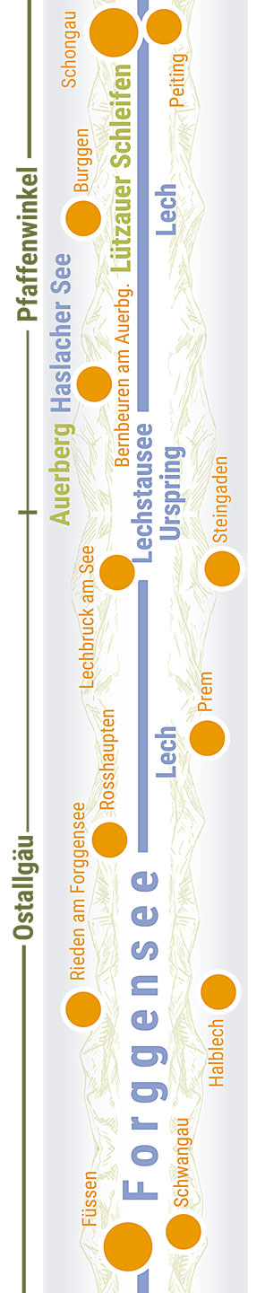
After you leave Landsberg, the cycling route departs from the old Roman road to traverse the picturesque villages of the Fuchstal valley: Oberdießen, Unterdießen, Asch, Leder and Denklingen. It then leads back to the Roman road, which traces the beautiful high banks of the Lech until Kinsau. There used to be a Roman fort on the Lorenzberg, a hill that is now home to the Lorenzkirche (Church of St. Laurence) in Epfach. A little Roman museum shows you what it looked like. Having left Kinsau, the route continues to follow the Roman road through Hochenfurch and Schwabniederhofen before reaching Altenstadt, the original parish of Schongau.

Food and drink

Questions and information about the section

Accommodation and camping

Radroute, Gastgeber, historische interaktive Karte mit Symbolen


Diesen interaktiven Bereich können Sie nutzen unter:
/en/road-biking/detailed-description-of-the-altinate-route

Do you have feedback or ideas for the cycling route? Let us know /


Diesen interaktiven Bereich können Sie nutzen unter:
/en/road-biking/detailed-description-of-the-altinate-route

jump back to the beginning of the detailed description of the Altinate cycling route / jump to northern Tyrol / jump to the Reschenpass / jump to Trento / jump to the whole history of the Via Claudia Augusta / jump to the history of the regions and towns along the Altinate route / jump to the ‘twenty-four maps through the centuries’ for each region along the Via Claudia Augusta / jump to the full spectrum of culture across the regions and towns (Altinate) / jump to the specialities of the regions and towns / jump to the wines of the regions and towns /


DRUCK
Radler in Tracht Schongau
Altenstadt, Basilika, Pfaffenwinkel, Foto Tschaikner
Luftbild Altstadt Schongau, Foto Schongau
Schongau Stadtmauer, Maxtor, Pfaffenwinkel, Foto Schongau
Schongau, Gaukler, Ballenhaus, Lechrain
Peiting Panorama, Pfaffenwinkel, Foto Peiting
Peitinger Villa Rustica, Frühling, Pfaffenwinkel, Foto Peitinger Villa Rustica
Villa Peiting Hypocausten Ausgrabung Pfaffenwinkel, Foto Peitinger Villa Rustica
Wieskirche, Pfaffenwinkel, Weilheim, Foto Via Claudia Augusta
Wieskirche Orgel, Pfaffenwinkel, Weilheim, Foto Wikimedia Mtag

Cycling route through Altenstadt, Schongau, Peiting

Radroute, historische interaktive Karte mit Symbolen

Just before you reach Altenstadt, you are once again faced with a decision: either visit the medieval old town of Schongau and the Villa Rustica in Peiting or trace the Roman road through Altenstadt. In the town of Altenstadt, you can see a reconstructed section of the Roman road and the Romanesque domed basilica. Now, cycle along the outskirts of Schonau towards Burggen.

Food and drink

Questions and information about the section

Accommodation and camping

Radroute, Gastgeber, historische interaktive Karte mit Symbolen


Diesen interaktiven Bereich können Sie nutzen unter:
/en/road-biking/detailed-description-of-the-altinate-route

Do you have feedback or ideas for the cycling route? Let us know /


Diesen interaktiven Bereich können Sie nutzen unter:
/en/road-biking/detailed-description-of-the-altinate-route

jump back to the beginning of the detailed description of the Altinate cycling route / jump to northern Tyrol / jump to the Reschenpass / jump to Trento / jump to the whole history of the Via Claudia Augusta / jump to the history of the regions and towns along the Altinate route / jump to the ‘twenty-four maps through the centuries’ for each region along the Via Claudia Augusta / jump to the full spectrum of culture across the regions and towns (Altinate) / jump to the specialities of the regions and towns / jump to the wines of the regions and towns /


DRUCK
Auerbergland
Bernbeuren Haslacher See Auerbergland, Foto Tschaikner
Burggen Bauernhof Baum St Anna Strasse Pfaffenwinkel, Foto Via Claudia Augusta
Kirche, Auerberg, Bernbeuren, Foto Anton Vorauer
Lechfloss, Lechbruck Am See, Ostallgäu, Foto Tschaikner
Rosshaupten, Pfannerhaus, Dokumentationszentrum, Foto Via Claudia Augusta
Forggensee, Schiff, Meilenstein, Tiefental, Rieden Am Forggensee, Ostallgäu, Foto Lois Lammerhuber

Cycling route through the Auerbergland

Radroute, historische interaktive Karte mit Symbolen

After Schongau, the cycling route leads through the hills of the Allgäu region: verdant forests and lush pastures, richly punctuated by lakes and ponds. This may well be the section of the route that follows the original Roman road for the greatest distance. It first takes you to Burggen, where you can see the St.-Anna-Straße, a listed street lined with typical, regional farmhouses. The next village is Lechbruck am See, a rafters’ village. Consider visiting the Auerberg and Bernbeuren with its Auerberg museum en route. On your way to Rosshaupten, you will pass many ponds, the Sameister-Kapelle chapel, a picturesque rest spot on a hill (featuring a much-photographed replica of a Roman milestone) and the Via Claudia Augusta Kunstpark (an open-air exhibition). Do not miss the Bavarian Via Claudia Augusta documentation center in Rosshaupten. From Rosshaupten, the cycling route follows the shore of the Forggensee reservoir until Rieden, where you can enjoy a ‘Roman beach’. Here, the original road is buried on the bottom of the reservoir. It becomes visible whenever the water level is low.

Food and drink

Questions and information about the section

Accommodation and camping

Radroute, Gastgeber, historische interaktive Karte mit Symbolen


Diesen interaktiven Bereich können Sie nutzen unter:
/en/road-biking/detailed-description-of-the-altinate-route

Do you have feedback or ideas for the cycling route? Let us know /


Diesen interaktiven Bereich können Sie nutzen unter:
/en/road-biking/detailed-description-of-the-altinate-route

jump back to the beginning of the detailed description of the Altinate cycling route / jump to northern Tyrol / jump to the Reschenpass / jump to Trento / jump to the whole history of the Via Claudia Augusta / jump to the history of the regions and towns along the Altinate route / jump to the ‘twenty-four maps through the centuries’ for each region along the Via Claudia Augusta / jump to the full spectrum of culture across the regions and towns (Altinate) / jump to the specialities of the regions and towns / jump to the wines of the regions and towns /


DRUCK
Radfahrer vor den Alpen
Der Lech und die berge bei Nacht in Füssen
Rathaus, Klosterhof, Museum, Foto Tschaikner
Reichenstraße, Fußgängerzone, Füsse, Foto Tschaikner
Schwangau, Kristalltherme
Römerbad, Foto Schwangau

Cycling route through Füssen and Schwangau

Radroute, historische interaktive Karte mit Symbolen

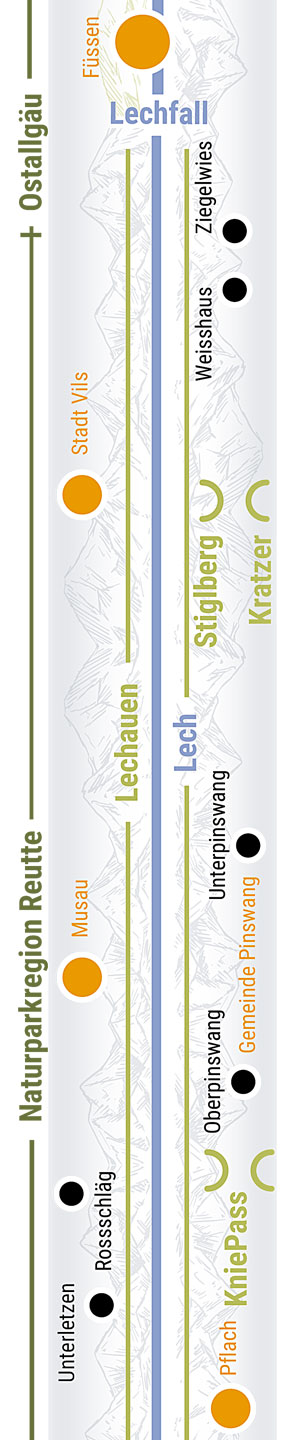
Initially, the route continues to run along the shore of the Forggensee reservoir. You are constantly treated to spectacular views of Neuschwanstein Castle and the city. The first landmark you will spot in Füssen is ‘Ludwig’s Festspielhaus’, a musical theater. Up until the tourist information office, you will be cycling along the old Roman road. From there, push your bike - on the original route - through the old town. The Reichenstraße is a pedestrian area today. Look up and you will see the High Castle of Füssen towering above the town. The actual cycling route runs around the west of the town center.  At the bridge over the Lech river, you can take a detour to Schwangau and the famous royal castles of the region. Alternatively, you can head straight to Pinswang in Tyrol along the partially graveled ‘Fürstenweg’ road. After crossing the bicycle bridge in Füssen, the route follows the Lech before taking you Tyrol along a beautiful country road.

Food and drink

Questions and information about the section

Accommodation and camping

Radroute, Gastgeber, historische interaktive Karte mit Symbolen


Diesen interaktiven Bereich können Sie nutzen unter:
/en/road-biking/detailed-description-of-the-altinate-route

Do you have feedback or ideas for the cycling route? Let us know /


Diesen interaktiven Bereich können Sie nutzen unter:
/en/road-biking/detailed-description-of-the-altinate-route

jump back to the beginning of the detailed description of the Altinate cycling route / jump to northern Tyrol / jump to the Reschenpass / jump to Trento / jump to the whole history of the Via Claudia Augusta / jump to the history of the regions and towns along the Altinate route / jump to the ‘twenty-four maps through the centuries’ for each region along the Via Claudia Augusta / jump to the full spectrum of culture across the regions and towns (Altinate) / jump to the specialities of the regions and towns / jump to the wines of the regions and towns /


DRUCK

Diesen interaktiven Bereich können Sie nutzen unter:
/en/road-biking/detailed-description-of-the-altinate-route

uC2xquICcPC


Netrak hcrud eid Ednesuatrhaj" (Noitide Noigerkraprutan Ettuer

Text of the historical map of ...
100 AD

Gateway to the Alps

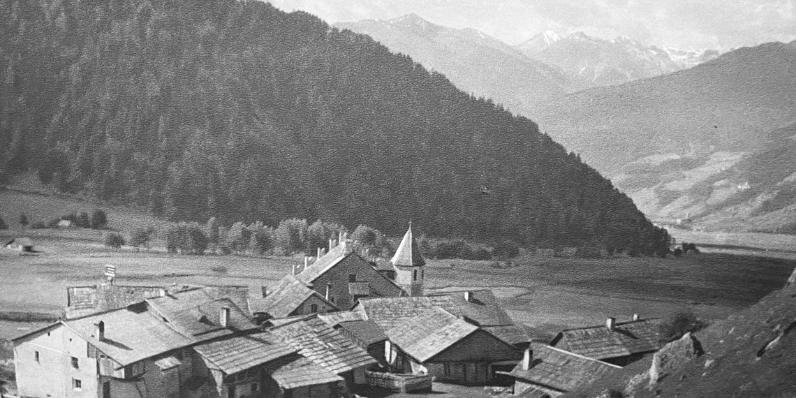
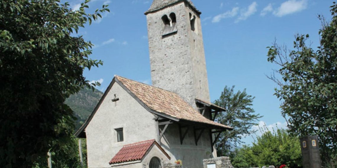
The Roman road entered the Alps as if through a gateway. As the Lech often occupied the entire valley, it already had to overcome two elevations up to the Reutte valley basin – between Stiglberg and Kratzer and at the Kniepass. The route of the Roman road remained in use until 1784 and the modern road still crosses the Kniepass today. Before climbing to Ehrenberg, the Via Claudia Augusta passed through the municipality of Breitenwang, where a road station (mansio) and the fifirst small settlement in the valley basin are thought to have been located. Reutte developed at a later stage – on the salt road. Breitenwang still remains the district’s ecclesiastic centre today.


1504

Reutte flourishes

With its extensive floodplains, the Lech also shaped the valley basin back in 1504 that depended significantly for its livelihood on the salt road between Hall in Tirol and the Lake Constance area. A bridge was built in 1464 between Lechaschau and Reutte that replaced the Lech ford near Höfen. With its salt depot and numerous roadside inns, Reutte grew into the centre of the Ausserfern district and in 1489 it was granted market rights by Sigesmund “the Rich”. Ehrenberg Castle throned above the valley. A wall blocked the gorge and all traffic had to pass through the customs station gate. There was an ironworks near Pflach. Vils, not yet part of Tyrol, was a town since 1327 and enclosed by a wall with two gates in the north and south.


1780

strongly fortified

Numerous fortifications in the border area between Bavaria and Tyrol shaped the area around 1780. In addition to the dam at Ehrenberg that had grown around two further fortresses, there were several outer fortresses. The market town of Reutte at their feet already had around 1,000 inhabitants and several new roads were completed. The road from Reutte via Vils to Kempten now passed by the walled city to the south, while that from Füssen to Pinswang went around the Stiglberg. The Ulrichs-brücke bridge was not constructed until 1914. Shortly after the turn of the century, the existing Bavarian local railway was also extended to join the Ausserfern railway that initially went to Reutte. The river was largely unregulated even around Reutte.


DRUCK
Brücke über dem Lechfall
Baumkronenweg Ziegelwies, Foto Walderlebniszentrum
Radweg zwischen Füssen und Pinswang
Vilseck
Scheiben Schießen Pinwang
Radweg in Lechauen
Blick Vom Vogelbeobachtungsturm in Lechau, Foto Tschaikner

Cycling route from Füssen to the valley basin of Reutte

Radroute, historische interaktive Karte mit Symbolen

Leave the old town of Füssen and cross the Lech river. Make sure you look back at the town from the south bank of the river: the view is wonderful! As you enter Austria, the cycling route runs parallel to the Lech river and the picturesque, old country road, parts of which are lined with trees. It departs from the river to cross the quaint villages of Unterpinswang and Oberpinswang before crossing the Kniepass to Pflach, just like the old Roman road did. At the edge of the Lech floodplains, the route crosses verdant pastures to lead you into the district capital of Reutte.

Food and drink

Questions and information about the section

For information, contact

Via Claudia Augusta Info
www.viaclaudia.org/en
info@viaclaudia.org
0043 664 27 63 555

For specific questions about the region, contact the

tourist board of the Reutte nature reserve region.
www.reutte.com/en
Untermarkt 34, 6600 Reutte
info@reutte.com
0043 5672 62336 40

Accommodation and camping

Radroute, Gastgeber, historische interaktive Karte mit Symbolen


Diesen interaktiven Bereich können Sie nutzen unter:
/en/road-biking/detailed-description-of-the-altinate-route

Do you have feedback or ideas for the cycling route? Let us know /


Diesen interaktiven Bereich können Sie nutzen unter:
/en/road-biking/detailed-description-of-the-altinate-route

jump back to the beginning of the detailed description of the Altinate cycling route / jump to northern Tyrol / jump to the Reschenpass / jump to Trento / jump to the whole history of the Via Claudia Augusta / jump to the history of the regions and towns along the Altinate route / jump to the ‘twenty-four maps through the centuries’ for each region along the Via Claudia Augusta / jump to the full spectrum of culture across the regions and towns (Altinate) / jump to the specialities of the regions and towns / jump to the wines of the regions and towns /


DRUCK
Dekanatspfarrkirche Breitenwang, Foto Breitenwang
Tourenradfahrer
Museum Grünes Haus Reutte Untermarkt Architekturmalerei
Denar Lugdunum
Kellerei Saal
Rennradfahrer Kreisverkehr Untermarkt
Burgruine Ehrenberg Morgennebel
Museum Ausstellung Dem Ritter Auf Der Spur Ehrenberg Burgenwelt
Ebikerin Qualität voller Schotter zwischen Ehrenberg und Heiterwang

Cycling route through Reutte to Ehrenberg

Radroute, historische interaktive Karte mit Symbolen

The cycling route runs from the fields near the Lech into the center of the market town, where it initially takes you through the Untermarkt pedestrian area. At the roundabout, you enter the Obermarkt. You are now cycling along the salt road. Do not miss the turns leading towards the hospital and, a little later, to Ehrenberg. As you ascend the hill towards Burgenwelt Ehrenberg (the Ehrenberg castle ensemble), the steeper salt road gives way to a gravel path. Unfortunately, the steadily ascending Roman road has only been preserved partially.

Food and drink

Tourenradfahrer

Questions and information about the section

For information, contact

Via Claudia Augusta Info
www.viaclaudia.org/en
info@viaclaudia.org
0043 664 27 63 555

For specific questions about the region, contact the

tourist board of the Reutte nature reserve region.
www.reutte.com/en
Untermarkt 34
info@reutte.com
0043 5672 62336 40

Accommodation and camping

Radroute, Gastgeber, historische interaktive Karte mit Symbolen


Diesen interaktiven Bereich können Sie nutzen unter:
/en/road-biking/detailed-description-of-the-altinate-route

Do you have feedback or ideas for the cycling route? Let us know /


Diesen interaktiven Bereich können Sie nutzen unter:
/en/road-biking/detailed-description-of-the-altinate-route

jump back to the beginning of the detailed description of the Altinate cycling route / jump to northern Tyrol / jump to the Reschenpass / jump to Trento / jump to the whole history of the Via Claudia Augusta / jump to the history of the regions and towns along the Altinate route / jump to the ‘twenty-four maps through the centuries’ for each region along the Via Claudia Augusta / jump to the full spectrum of culture across the regions and towns (Altinate) / jump to the specialities of the regions and towns / jump to the wines of the regions and towns /


"4 NETRAK HCRUD EID EDNESUATRHAJ" (NOITIDE RELORIT ZTIPSGUZ ANERA

Text of the historical map of ...
400 AD

Masterful roads

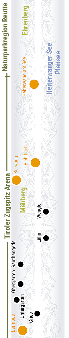
The aim of the Roman road builders was to construct the quickest route from the Adriatic and the Po to the limes. Even in Tirol the Via Claudia Augusta therefore only has four hairpin bends. Nevertheless, the ffiirst trans-European road has a relatively constant incline even over the challenging sections across the passes. Another outstanding feat is the section on 1,000 tree trunks across the ‘Moos’ wetland habitat between Lermoos, Ehrwald and Biberwier, near to which two settlements were located – one in Ehrwald that already existed before the arrival of the Romans and continued to exist during the Roman era, and one founded by the Romans in the area surrounding the road station in Biberwier, immediately in front of the Fern Pass.


1599

Living from the road

While the Roman road was sustained by the fiffiirst European single market with no customs or tolls, the era of the salt road was shaped by the transport of goods. The local residents had the exclusive privilege of transporting certain goods such as salt from one place to the next. The population along the route benefiffiited from both of these systems. The population of Zwischentoren, the area between the Ehrenberg and Fernstein gates, is thought only to have become properly aware of this when the Arlberg Pass was made navigable again. As the traffiffiic shifted away, they became desperately poor. After meeting to say farewell at Austria’s only guild church in Bichlbach, many people from the Ausserfern district were forced to move as building workers to the neighbouring regions to the north. Children also moved away as ‘Swabian children’.


1926

Further development

A new wave of development started in the second half of the nineteenth century from Zwischentoren, the area between the two gates of Ehrenberg and Fernstein through which the Fern Pass road passed until 1856. It was then that today’s road was built. In 1913 the Ausserfern railway was extended that had previously terminated in Reutte. As an alternative to the completed route via Garmisch and on to Innsbruck, there was also talk of a line across the Gaistal, Leutasch and Seefeld. Furthermore, there were plans for a rail link to Imst with a summit tunnel through the Fern Pass of the sort currently being planned for cars. The Tyrolean Zugspitze Railway was one of the fiffiirst mountain railways and promot


DRUCK
Heiterwang See Schiff Einsteigen, Foto Anton Vorauer
Rad Heiterwang Bichlbach
Salzstrasse
Zunftkirche Bichbach Tiroler Zugspitz Arena, Foto Anton Vorauer
Zunftmuseum Bichlbach
Musikkapelle Bichlbach
Radweg Heiterwang Bichlbach Tiroler Zugspitz Arena, Foto Anton Vorauer

Cycling route to Heiterwang, Bichlbach, Wengle, Lähn

Radroute, historische interaktive Karte mit Symbolen

Just like the Roman route and the salt road, our cycling route runs through the gate of the Klause Ehrenberg fortress. For many centuries, this was the only way of crossing the reservoir, where carters had to pay a toll. The route then continues along forest trails to Heiterwang am See, taking you through the Klausenwald forest. You will be following the old Roman road all the way to the edge of the town. The salt road will lead you through the town itself in a wide circle. Continue to Bichlbach along picturesque pastures. In the distance, you will see the Mähberg, a mountain whose pastures were mowed until the late twentieth century. The cycling road takes you through Bichlbach along the Dorfstraße, which is largely equivalent to the Roman road. Cycle past pastures and through forests to reach Wengle, Lähn and the valley between Lermoos, Ehrwald and Biberwier.

Food and drink

Questions and information about the section

For information, contact

Via Claudia Augusta Info
www.viaclaudia.org/en
info@viaclaudia.org
0043 664 27 63 555

For specific questions about the region, contact the

tourist board of the Tiroler Zugspitz Arena.
www.zugspitzarena.com/en
Oberdorf 5, 6611 Heiterwang am See
Wahl 31a, 6621 Bichlbach
info@zugspitzarena.com
0043 5673 20000

Accommodation and camping

Radroute, Gastgeber, historische interaktive Karte mit Symbolen


Diesen interaktiven Bereich können Sie nutzen unter:
/en/road-biking/detailed-description-of-the-altinate-route

Do you have feedback or ideas for the cycling route? Let us know /


Diesen interaktiven Bereich können Sie nutzen unter:
/en/road-biking/detailed-description-of-the-altinate-route

jump back to the beginning of the detailed description of the Altinate cycling route / jump to northern Tyrol / jump to the Reschenpass / jump to Trento / jump to the whole history of the Via Claudia Augusta / jump to the history of the regions and towns along the Altinate route / jump to the ‘twenty-four maps through the centuries’ for each region along the Via Claudia Augusta / jump to the full spectrum of culture across the regions and towns (Altinate) / jump to the specialities of the regions and towns / jump to the wines of the regions and towns /


DRUCK
Ebikerin vor Zugspitze
Tiroler Zugspitz Arena Panorama
Grabung Prügelweg Lermoos
Ehrwald Kirchplatz
Brauchtum Bergfeuer Ehrwald
Biberwier
Adlergemme

Cycling route to Lermoos, Ehrwald, Biberwier

Radroute, historische interaktive Karte mit Symbolen

At the edge of Lermoos, the cycling route runs underneath the Fernpass highway – today’s incarnation of the Via Claudia Augusta, in a way. A little further down the road, the highway disappears in to the Leermoos tunnel. You will be following the dam of the Ausserfernbahn railway before heading towards Biberwier through the beautiful “Moos” marshlands, which stretch between the three towns. In Biberwier, you will pass the location of a Roman road station that was unearthed by archaeologists a few years ago. Having crossed the quaint little town, you start the ascent to the Fernpass.

Food and drink

Questions and information about the section

For information, contact

Via Claudia Augusta Info
www.viaclaudia.org/en
info@viaclaudia.org
0043 664 27 63 555

For specific questions about the region, contact the

tourist board of the Tiroler Zugspitz Arena
www.zugspitzarena.com/en
Unterdorf 15, 6631 Lermoos
Kirchplatz 1, 6632 Ehrwald
Fernpaßstraße 27, 6633 Biberwier
info@zugspitzarena.com
0043 5673 20000

Accommodation and camping

Radroute, Gastgeber, historische interaktive Karte mit Symbolen


Diesen interaktiven Bereich können Sie nutzen unter:
/en/road-biking/detailed-description-of-the-altinate-route

Do you have feedback or ideas for the cycling route? Let us know /


Diesen interaktiven Bereich können Sie nutzen unter:
/en/road-biking/detailed-description-of-the-altinate-route

jump back to the beginning of the detailed description of the Altinate cycling route / jump to northern Tyrol / jump to the Reschenpass / jump to Trento / jump to the whole history of the Via Claudia Augusta / jump to the history of the regions and towns along the Altinate route / jump to the ‘twenty-four maps through the centuries’ for each region along the Via Claudia Augusta / jump to the full spectrum of culture across the regions and towns (Altinate) / jump to the specialities of the regions and towns / jump to the wines of the regions and towns /


"4 Netrak hcrud eid Ednesuatrhaj" (Noitide Tsmi

historical map of ...
100 AD

Old settlement area

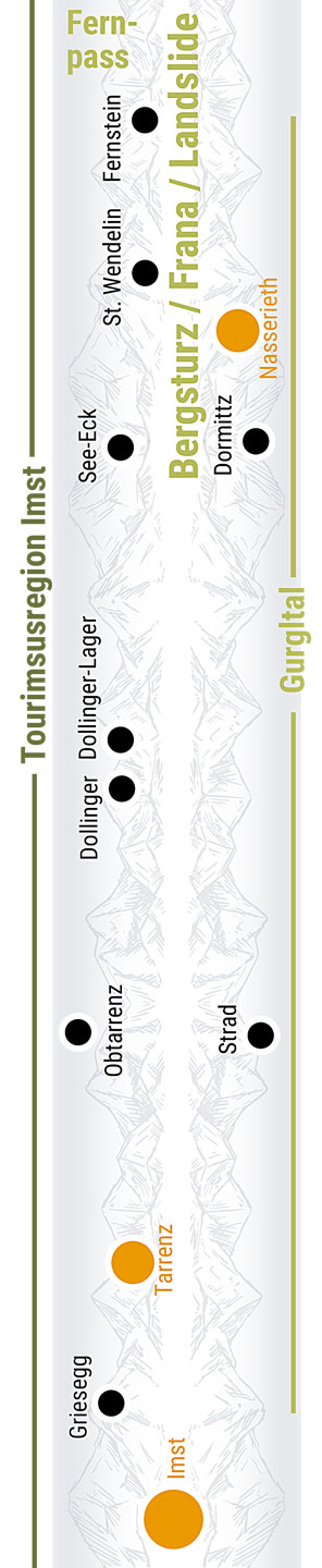
There is documentary evidence of “Oppidum Humiste” dating back to 763. Oppidum was a fortifified pre-Roman settlement. Its mention after the Roman era points towards continuous settlement since pre-Roman times that will have been concentrated on the hill above Imst town centre. There are also indications of prehistoric settlement in Dormitz near Nassereith. The Romans established road stations in both places along the Via Claudia Augusta, around which settlements developed. In Imst, which was the most important settlement between Füssen and Merano, this was probably parallel to the pre-Roman settlement. There was also prehistoric and Roman settlement on the sunny slopes of the Tschirgant, in Karrösten and Karres.


1550

Mining stronghold

The area around the Via Claudia Augusta between Biberwier and the Inn Valley was an important mining centre in multiple respects. Signifificant historic mining districts were located in the Mieming mountain range in the east, the Lechtal Alps in the north and on the slopes of the Tschirgant in the south. Numerous tunnel entrances await discovery on close examination particularly in the Wannig rock face above Nassereith. Above all lead was mined as a grey ore for silver mining in Schwaz and Zink. Furthermore, Imst, alongside its importance as a market place and traffic hub, was the seat of the mining court covering an area that reached to the Ausserfern district and Vorarlberg.


1901

Long prevented town

Imst has for thousands of years been the most important settlement between Füssen and Merano and an important traffiffiific hub. It has had market rights since late medieval times and from the fifteenth to the seventeenth centuries it was the seat of a mining court covering an area that reached to the Ausserfern district and Vorarlberg. Had the infflluential lords of Starkenberg not opposed this because Imst would then have been directly subordinate to the territorial prince, the Gurgltal metropolis would have been a town with its own walls for 700 years. Following a ffiire in 1822 to which 206 out of 220 houses fell victim, Imst was rebuilt and ffiinally received town rights in 1898. Imst is also renowned for its bird breeders and dealers.

DRUCK
Rad Brücke Schloss Fernstein
Fernpass Blindsee, Foto Anton Vorauer
Fernpass Salzstrasse Mittelalter, Foto Anton Vorauer
Fernsteinsee Schloss Fernpass
Radshuttle Radfahrer Fernpass Fernstein
Tourenradler Fernstein
Hotel Schloss Fernstein
Fernstein Gemälde Frühneuzeitliche Strasse

Cycling across the Fernpass

Radroute, historische interaktive Karte mit Symbolen

Crossing the pass on your own is hard work. But your efforts will pay off: this section of the route treats you to incredible views of the landslide site and multiple longer stretches of the Roman Via Claudia Augusta and its medieval successor road. And you will certainly feel accomplished when you reach the top. We recommend that you allow for more time per kilometer than you do for other sections. You might end up pushing your bicycle a few hundred meters. The Romans doubtlessly got off their carriages often to help the draft animals.  If you would rather not dare the climb, you can book a shuttle by text message and be taken over the pass in comfort. From Biberwier, the cycling route runs along the country road for a while. It then forks to the left, and a forest path takes you past the Weissensee lake to the old top of the Fernpass. In one spot, the forest path briefly approaches the national road. If you head to the other side, you can take a little road to the Blindsee lake, a popular alpine swimming lake. Once you reach the old  top of the Fernpass, which dates back to the Romans, you will have spectacular views of the landslide site and at least five roads that led across the Fernpass over the centuries. The clearly visible track of the Roman road forks off the forest road to the left a little later and gently slopes down the hill. Initially, the cycling route follows the forest road. It then forks towards the current top of the Fernpass. Having crossed the plateau, it runs along the late medieval road to the ‘Afrigall’, a section of the mountain lowered by a landslide. Cycle along forest roads and some narrow gravel paths until you reach Schloss Fernstein castle, where the route leads you through the gate of the former toll station.

Food and drink

Questions and information about the section

For information, contact

Via Claudia Augusta Info
www.viaclaudia.org/en
info@viaclaudia.org
0043 664 27 63 555

For specific questions about the region up to the Fernpass, contact the

tourist board of the Tiroler Zugspitz Arena
www.zugspitzarena.com/en
Unterdorf 15, 6631 Lermoos
Kirchplatz 1, 6632 Ehrwald
Fernpaßstraße 27, 6633 Biberwier
info@zugspitzarena.com
0043 5673 20000

For specific questions about the region up to the Fernpass, contact

Imst Tourismus
www.imst. at/en
Postplatz 28, 6465 Nassereith
Johannesplatz 4, 6460 Imst
info@imst.at
0043 5412 6910

Accommodation and camping

Radroute, Gastgeber, historische interaktive Karte mit Symbolen


Diesen interaktiven Bereich können Sie nutzen unter:
/en/road-biking/detailed-description-of-the-altinate-route

Do you have feedback or ideas for the cycling route? Let us know /


Diesen interaktiven Bereich können Sie nutzen unter:
/en/road-biking/detailed-description-of-the-altinate-route

jump back to the beginning of the detailed description of the Altinate cycling route / jump to northern Tyrol / jump to the Reschenpass / jump to Trento / jump to the whole history of the Via Claudia Augusta / jump to the history of the regions and towns along the Altinate route / jump to the ‘twenty-four maps through the centuries’ for each region along the Via Claudia Augusta / jump to the full spectrum of culture across the regions and towns (Altinate) / jump to the specialities of the regions and towns / jump to the wines of the regions and towns /


DRUCK
Dormitz Nassereith Richtung Fernstein
Nassereith See Gurgltal
Fasnachtshaus Nassereith
Gurgltal Imst
Knappenwelt Bergbau Pochwerk
Tarrenz Richtung Imst
Radfahrer Gurgltal

Cycling route to Fernstein, Nassereith, Tarrenz, Imst

Radroute, historische interaktive Karte mit Symbolen

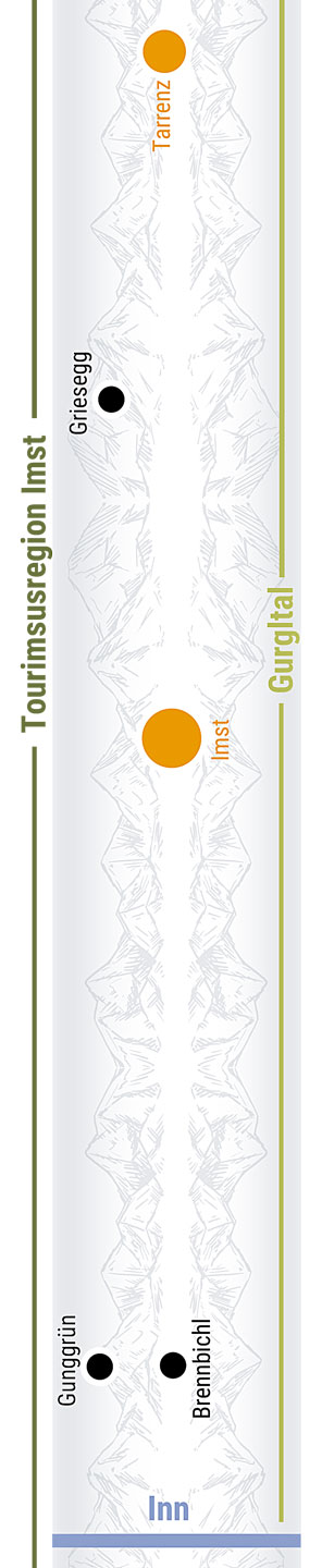
The cycling route takes you across forest roads, a dedicated cycling path and the village road as you cycle from Fernstein to the picturesque center of Nassereith. The portals in the mountain reflect the mining heritage of this town. Continue along the pastures underneath Dormitz to cross the Strader Wald forest. The beautiful forest path largely follows the old Roman road. Soon after Strad, you reach the Knappenwelt Gurgltal, an outdoor mining museum. The cycling route then follows the Roman road in crossing the valley. From Tarrenz on, it leads you towards Imst on the sunny side of the valley.

Food and drink

Questions and information about the section

For information, contact

Via Claudia Augusta Info
www.viaclaudia.org/en
info@viaclaudia.org
0043 664 27 63 555

For specific questions about the region, contact the

Touristic information by Imst Tourismus
www.imst. at/en
Postplatz 28, 6465 Nassereith
Johannesplatz 4, 6460 Imst
info@imst.at
0043 5412 6910

Accommodation and camping

Radroute, Gastgeber, historische interaktive Karte mit Symbolen


Diesen interaktiven Bereich können Sie nutzen unter:
/en/road-biking/detailed-description-of-the-altinate-route

Do you have feedback or ideas for the cycling route? Let us know /


Diesen interaktiven Bereich können Sie nutzen unter:
/en/road-biking/detailed-description-of-the-altinate-route

jump back to the beginning of the detailed description of the Altinate cycling route / jump to northern Tyrol / jump to the Reschenpass / jump to Trento / jump to the whole history of the Via Claudia Augusta / jump to the history of the regions and towns along the Altinate route / jump to the ‘twenty-four maps through the centuries’ for each region along the Via Claudia Augusta / jump to the full spectrum of culture across the regions and towns (Altinate) / jump to the specialities of the regions and towns / jump to the wines of the regions and towns /


DRUCK
Imst Meran Des Nordens
Laurentiuskirchlein Imst
Kramergasse Imst
Imst Rosengartenschlucht
Imst Schemenlaufen

Cycling route through Imst

Radroute, historische interaktive Karte mit Symbolen

Cycle across the splendid pastures of the Gurgltal valley to merge with the historical main road just ahead of the parish church, then enter Imst. The old road connects the two historical districts of Obermarkt and Untermarkt with each other. Beyond the parish church, it is largely identical to the Roman road. Just before the end of the historical old town, the route slopes towards Untermarkt, where it crosses the town square and leaves the town through the backdoor  towards the Inn river.

Food and drink

Questions and information about the section

For information, contact

Via Claudia Augusta Info
www.viaclaudia.org/en
info@viaclaudia.org
0043 664 27 63 555

For specific questions about the region, contact the

Touristic information by Imst Tourismus
www.imst. at/en
Johannesplatz 4, 6460 Imst
An der Au 1, Erlebnis-Rast-Stätte Trofana Tyrol, 6493 Mils bei Imst
info@imst.at
0043 5412 6910

Accommodation and camping

Radroute, Gastgeber, historische interaktive Karte mit Symbolen


Diesen interaktiven Bereich können Sie nutzen unter:
/en/road-biking/detailed-description-of-the-altinate-route

Do you have feedback or ideas for the cycling route? Let us know /


Diesen interaktiven Bereich können Sie nutzen unter:
/en/road-biking/detailed-description-of-the-altinate-route

jump back to the beginning of the detailed description of the Altinate cycling route / jump to northern Tyrol / jump to the Reschenpass / jump to Trento / jump to the whole history of the Via Claudia Augusta / jump to the history of the regions and towns along the Altinate route / jump to the ‘twenty-four maps through the centuries’ for each region along the Via Claudia Augusta / jump to the full spectrum of culture across the regions and towns (Altinate) / jump to the specialities of the regions and towns / jump to the wines of the regions and towns /


"4 Netrak hcrud eid Ednesuatrhaj" (Noitide Kcednal, TsewlOrit

Text of the historical maps of ...
before the year 0

Early densely populated

Already in early history, the area around Landeck was relatively densely populated. Above Schönwies, in Stanz and Grins, in Perjen, in Fließ, at the entrance to the Kaunertal, in Fiss and Serfaus, ... - on every sunny slope and every high terrace settlements are proven or at least there are indications of settlement. The settlements were connected by cart paths. In addition to one in the Inn valley, there was also a shortcut from the Kaunertal valley over the Piller Sattel to Imst. Above Fliess was a burnt offering site where gods were invoked for centuries, until Roman times. In the archaeological museum of Fliess you can marvel at early historical finds from this time, which you can otherwise only find in such abundance and quality in large cities.


450

early Christian churches

In the Landeck area the Via Claudia Augusta largely ran along the slope – the section between the Inn bridge near Starkenbach and Landeck followed the striking and picturesque route over the “Platte” to Fließ, where ruts in the rock dating from different periods tell stories about the road.  The Via Claudia Augusta only left the slope in the vicinity of Landeck Castle – presumably because there was a road station there and the road branched off over the Arlberg. The important transport connection not only brought economic development but also a lively cultural exchange that is reflected among other things in the area’s early Christianisation. The parish church in Landeck and St. Lawrence’s Church on the hill above Imst have their roots in the fififth century, while the ‘Maaßkirche’ church next to the archaeological museum in Fließ dates back to the sixth century.


1787

Landeck as a transport hub

Two long-distance roads already converged for the first time back in Roman times at the confluence of the Sanna and the Inn. In 1787 the road to Vorarlberg, that had for a long time no longer been navigable, was renewed and restored to new life and the valley basin finally became a transport hub. The rest was done by the construction of the Arlberg railway in 1884, during which 800 jobs were also created and the population grew rapidly. Around 1900, the municipalities of Perfuchs and Angedair were merged into Landeck, that gained market rights in 1904 and became a town in 1923. Landeck had already been a municipal centre since 1868 when there was not yet even a place called Landeck but only the castle. The loser of the shift of the east-west traffic corridor to the Arlberg route was incidentally Zwischentoren, between Fernstein and Reutte. Many of the bitterly poor people of Ausserfern consequently became migrant workers in the more prosperous neighbouring regions to the north.


DRUCK
Tourenradfahrer zwischen Imst und Landeck
Kornburg Imst Schönwies
Mils Au, Foto Imst Tourismus
Mils bei Imst
Mittelalterliche Geleise Mils

Cycling route from Imst to the Landeck region

Radroute, historische interaktive Karte mit Symbolen

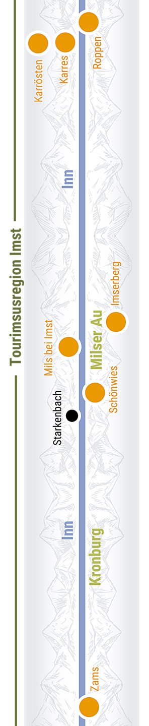
From Brennbichl (a district of Imst), the Via Claudia Augusta cycling route runs parallel to the Inn cycling route. It takes you past the Trofana Tyrol motorway service area and the Milser Au meadow, both perfect for an extended rest. The village road that takes you through Mils is largely equivalent to the Roman road. After you cross the Inn river, the route takes you through the elongated village of Schönwies, far away from traffic. Past the village, the cycling route passes the head of the old bridge over the Inn, which stood in the same place as an older Roman bridge until the 19th century. Shortly after you cycle through an underpass underneath the railway tracks, you have an opportunity to visit Kronburg castle. Afterwards, the route takes you through verdant meadows towards Zams. Don’t miss the Roman wheel tracks in the rocks at the rest stop on the hill.

Food and drink

Questions and information about the section

For information, contact

Via Claudia Augusta Info
www.viaclaudia.org/en
info@viaclaudia.org
0043 664 27 63 555

For specific questions about the region up to Kronburg, contact

Imst Tourismus
www.imst. at/en
Johannesplatz 4, 6460 Imst
An der Au 1, Erlebnis-Rast-Stätte Trofana Tyrol, 6493 Mils bei Imst
info@imst.at
0043 5412 6910

For specific questions about the region from Kronburg onwards, contact

the tourist information office of TirolWest
www.tirolwest.at/en
Hauptplatz 6, 6511 Zams
info@tirolwest.at
0043 5442 65600

Accommodation and camping

Radroute, Gastgeber, historische interaktive Karte mit Symbolen


Diesen interaktiven Bereich können Sie nutzen unter:
/en/road-biking/detailed-description-of-the-altinate-route

Do you have feedback or ideas for the cycling route? Let us know /


Diesen interaktiven Bereich können Sie nutzen unter:
/en/road-biking/detailed-description-of-the-altinate-route

jump back to the beginning of the detailed description of the Altinate cycling route / jump to northern Tyrol / jump to the Reschenpass / jump to Trento / jump to the whole history of the Via Claudia Augusta / jump to the history of the regions and towns along the Altinate route / jump to the ‘twenty-four maps through the centuries’ for each region along the Via Claudia Augusta / jump to the full spectrum of culture across the regions and towns (Altinate) / jump to the specialities of the regions and towns / jump to the wines of the regions and towns /


DRUCK
Schloss Landeck, Foto Albin Niederstrasser
Zammer Lochputz
Genussregion Sortiment
Museum Fliess Aussen
Bronzezeitlicher Kammhelm Museum Fliess
Brennereidorf Stanz, Foto Tirol West - Albin Niederstrasser
Kaunergrat Murmeltier Naturpark Tirol West
Keimlinge Closeup Genussregion Tirol West
Schnaps, Likör, Brot, Marmelade, Genussregion Tirol West
Tiroler Edle

Cycling route through Zams, Landeck and Fließ

Radroute, historische interaktive Karte mit Symbolen

The cycling route runs to Zams, crosses the Inn river shortly before the center, and follows the river through the district of Perjen and Bruck to the center of the county capital. You will pass the Zammer Lochputz gorge with its splendid waterfall. Cross the town center on the historical Malserstraße, which is currently experiencing a second heyday as an important business street. A bit further up, you will see the parish church and Schloss Landeck castle. The route now crosses the Inn river again and leads you to Urgen (a district of Fließ) on the left bank of the river. Here, it follows the old national road for a while, then ascends towards the elevated center of Fließ, where you can visit the Via Claudia Augusta documentation center. As you continue, you cross the Inn another three times and get to see the main river of the state of Tyrol from different angles.

Regional cuisine like two millennia ago

Questions and information about the section

For information, contact

Via Claudia Augusta Info
www.viaclaudia.org/en
info@viaclaudia.org
0043 664 27 63 555

For specific questions about the region, contact the

tourist board of TirolWest.
www.tirolwest.at/en
Hauptplatz 6, 6511 Zams
info@tirolwest.at
0043 5442 65600

Accommodation and camping

Radroute, historische interaktive Karte mit Symbolen


Diesen interaktiven Bereich können Sie nutzen unter:
/en/road-biking/detailed-description-of-the-altinate-route

Do you have feedback or ideas for the cycling route? Let us know /


Diesen interaktiven Bereich können Sie nutzen unter:
/en/road-biking/detailed-description-of-the-altinate-route

jump back to the beginning of the detailed description of the Altinate cycling route / jump to northern Tyrol / jump to the Reschenpass / jump to Trento / jump to the whole history of the Via Claudia Augusta / jump to the history of the regions and towns along the Altinate route / jump to the ‘twenty-four maps through the centuries’ for each region along the Via Claudia Augusta / jump to the full spectrum of culture across the regions and towns (Altinate) / jump to the specialities of the regions and towns / jump to the wines of the regions and towns /


"4 Netrak hcrud eid Ednesuatrhaj" (Noitide Sreduan, Relorit Dnalrebo

Text of the historical maps of ...
100 AD

Road mostly at valley floor

Owing the narrowness of the valley, which was at risk of rockfall and often entirely flooded by the Inn, the Via Claudia Augusta ran along the slope between Landeck and Fließ, across the Fliesser Platte in which the carts left traces in the rock in the different periods. Back in the valley, the Roman road was then able to continue – with various river crossings – along the valley floor until Altfinstermünz, as nature narrowed the course of this section of the Inn. From Finstermünz the road climbed steadily at a gradient of 11% up through the gorge to Inutrium, the only road station for which there is written evidence, shortly before reaching its highest point, the Reschen Pass. There are thought to have been two more road stations between Prutz and Pfunds. Fließ and Inutrium were definitely inhabited.


1530

Road and mining

The Roman road largely remained in use in the Middle Ages and modern era. Fortresses such as Pidenegg, Pernegg, Laudegg, Siegmundsriedt, Finstermünz and Naudersberg lined the transport routes. Apart from the main roads, there were almost only mule tracks. As well as self-sufficient farming and earnings opportunities in connection with the road, income was also generated by mining – first in Kaunertal, then in Bergtal and later in Platzertal. Ore was also extracted in Serfaus and smelted in Fließ.


1910

New transport routes

For a long time there were discussions about how to modernise the Reschenstrasse. The modern road builders finally got their way and the road was constructed between 1852 and 1856 with hairpin bends and galleries many of which are still in use today. Roads were also built to the Engadine, to Samnaun and to the mines of Platzertal. The ore was also transported with a goods cable lift. As well as investments in the roads, there were also two different plans for a rail link across the Reschen Pass for which a large number of tunnels would have been necessary. The northernmost fortress of Austria-Hungary facing Italy bears witness to the strategically important location of the pass.


DRUCK
Tiroler Oberland Radler Familie
Nebelstimmung Tiroler Oberland Oberinntal
Altfinstermünz Pfunds Nauders Reschenpass, Foto Lammerhuber
Schloss Siegmundsried
Kaunertaler Gletscherstrasse Stausee
Pfunds Turmloch
Tösens Römerbrücke
Pfunds
Rad Tiroler Oberland Tschey
Tiroler Oberland Spiss Sommer Gesamtansicht

Cycling route through Prutz, Ried im Oberinntal, Tösens, Pfunds

Radroute, historische interaktive Karte mit Symbolen

The cycling route continues along the old national road, which largely corresponds to the Roman road. Today, it is the domain of hikers, cyclists and those who live nearby. Burg Laudegg castle thrones above you as you cycle through verdant meadows towards Prutz, where the Roman road crosses the Inn river. After you cross the center of Prutz, you enter a new cycling path which takes you past the local swimming lake to Ried im Oberinntal and Tösens. Towards Pfunds, the cycling route takes you past picturesque ponds along the old national road, following the Roman road on the western slopes of the mountain. It then crosses the valley and leads you into the village of Pfunds. An old tower bridge over the Inn incorporates Stuben, the historically grown center of the village, into the cycling route. It then follows the Inn river to the historical toll station of Altfinstermünz. Before reaching the toll station, the Roman road (identical with this section of the cycling route) runs along the external border between the EU and Switzerland.

Regional cuisine like two millennia ago

Questions and information about the section

For information, contact

Via Claudia Augusta Info
www.viaclaudia.org/en
info@viaclaudia.org
0043 664 27 63 555

For specific questions about the region, contact the

tourist board of the Reutte nature reserve region.
www.tiroler-oberland.com
Hintergasse 2, 6522 Prutz
Kirchplatz 48, 6531 Ried im Oberinntal
Stuben 40, 6542 Pfunds
office@tiroler-oberland.com
0043 50 225 100

Accommodation and camping

Radroute, Gastgeber, historische interaktive Karte mit Symbolen


Diesen interaktiven Bereich können Sie nutzen unter:
/en/road-biking/detailed-description-of-the-altinate-route

Do you have feedback or ideas for the cycling route? Let us know /


Diesen interaktiven Bereich können Sie nutzen unter:
/en/road-biking/detailed-description-of-the-altinate-route

jump back to the beginning of the detailed description of the Altinate cycling route / jump to northern Tyrol / jump to the Reschenpass / jump to Trento / jump to the whole history of the Via Claudia Augusta / jump to the history of the regions and towns along the Altinate route / jump to the ‘twenty-four maps through the centuries’ for each region along the Via Claudia Augusta / jump to the full spectrum of culture across the regions and towns (Altinate) / jump to the specialities of the regions and towns / jump to the wines of the regions and towns /


DRUCK
Reschenpass
xy
Nauders am Reschenpass von Oben, Foto Manuel Baldauf
Nauders am Reschenpass Schloss burg Naudersberg, Foto Daniel Zangerl
Reschenpass
st valentin
Graun
Dorf Reschen Von Oben
Festung Nauders
Nauders am Reschenpass Naturdenkmal Schwarzer See, Foto Martin Lugger
Nauders am Reschenpass Goldwasser, Foto Daniela Zengerl

Cycling route through Nauders, Reschen/Resia, Graun/Curon, St. Valentin/San Valentino

Radroute, historische interaktive Karte mit Symbolen

All passes along the Via Claudia Augusta can be crossed by bike shuttle. Of course, you can also choose to attempt the ascent yourself. The bus to the Reschenpass, which runs several times a day, has a large bicycle trailer attached to it. If you decide to cycle to the peak of the route yourself, you will first follow a beautiful path along the Inn river to Altfinstermünz before continuing to Martina in Switzerland. (You will cross the external border of the EU: do not forget your passport!) The route then snakes up to the Norbertshöhe pass and runs towards Nauders on the Reschenpass. From there, you follow the old national road to the Reschenpass. Today, it is a single-lane road that is only used by cyclists, pedestrians and local residents. It snakes across beautiful mountain pastures, precisely following one track of the old Roman road (photo point). Unlike the Etschtal cycle path, the Via Claudia Augusta route runs along the same shore of the lakes as the old Roman road did. Today, the Roman road is buried at the bottom of the lake together with the village of Altgraun and its church. After passing the Reschen dam, you enter the quaint village and afterwards the Mals/Malles heath, which the Roman road used to cross.

Food and drink

Reschenpass

Questions and information about the section

For information, contact

Via Claudia Augusta Info
www.viaclaudia.org/en
info@viaclaudia.org
0043 664 27 63 555

For specific questions about the region up to the Reschenpass, contact the

tourist information office of Nauders am Reschenpass:
www.nauders.com
Doktor-Tschiggfrey-Str. 66, 6543 Nauders
office@nauders.com
0043 50 225 400

For specific questions about the region from the Reschenpass onwards, contact

the tourist information office of Vinschgau
www.vinschgau.net/en
info@vinschgaumarketing.net
0039 0473 620 480

Accommodation and camping

Radroute, Gastgeber, historische interaktive Karte mit Symbolen


Diesen interaktiven Bereich können Sie nutzen unter:
/en/road-biking/detailed-description-of-the-altinate-route

Do you have feedback or ideas for the cycling route? Let us know /


Diesen interaktiven Bereich können Sie nutzen unter:
/en/road-biking/detailed-description-of-the-altinate-route

jump back to the beginning of the detailed description of the Altinate cycling route / jump to northern Tyrol / jump to the Reschenpass / jump to Trento / jump to the whole history of the Via Claudia Augusta / jump to the history of the regions and towns along the Altinate route / jump to the ‘twenty-four maps through the centuries’ for each region along the Via Claudia Augusta / jump to the full spectrum of culture across the regions and towns (Altinate) / jump to the specialities of the regions and towns / jump to the wines of the regions and towns /


DRUCK
Radroute Oberer Vinschgau
Radler Marienberg
Rad Abschnitt
Vinschgau, Glurns, Tor, Gasse, Foto: Vinschgau Marketing, Frieder Blickle
Radler Michlkandl Glurns
Tartscher Bichl Mals Marienberg

Cycling route Mals/Malles heath and Prad am Stilfser Joch/Prato Allo Stelvio

Radroute, historische interaktive Karte mit Symbolen

The Vinschgau cycling route runs along the edge of the Mals/Malles heath, the largest alluvial fan of the Alps. It takes you past the picturesque canals of the health towards the hamlet of Burgeis/Burgusio, overlooked by the Marienberg monastery. Continue to the edge of Mals/Malles, which is lined with many small towers, and cross the hamlets of Schleis/Clusio and Laatsch/Laudes before entering the medieval town of Glurns/Glorenza. The next section of the route takes you through meadows and apple orchards to Spondinig/Spondigna. Before entering the village, you will be treated to a sweeping view of Schluderns/Sluderno and Churburg castle on one side and the ruins of Lichtenberg castle on the other side. When you enter Mals/Malles, you are on the Sonnenberg, which is covered in dry grassland. The route finally crosses the valley through a marshland. At the foothills of the Stilfser Joch pass lies Prad/Prato.

Sights

Oberer Vinschgau

Food and drink

Oberer Vinschgau

Further information

For information about the entire route, contact

Via Claudia Augusta Info
www.viaclaudia.org/en
info@viaclaudia.org
0043 664 27 63 555

For specific questions about the region, contact the

Vinschgau tourist information
www.vinschgau.net/en
info@vinschgaumarketing.net
0039 0473 620 480

Accommodation and camping

Radroute, Gastgeber, historische interaktive Karte mit Symbolen


Diesen interaktiven Bereich können Sie nutzen unter:
/en/road-biking/detailed-description-of-the-altinate-route

Do you have feedback or ideas for the cycling route? Let us know /


Diesen interaktiven Bereich können Sie nutzen unter:
/en/road-biking/detailed-description-of-the-altinate-route

jump back to the beginning of the detailed description of the Altinate cycling route / jump to northern Tyrol / jump to the Reschenpass / jump to Trento / jump to the whole history of the Via Claudia Augusta / jump to the history of the regions and towns along the Altinate route / jump to the ‘twenty-four maps through the centuries’ for each region along the Via Claudia Augusta / jump to the full spectrum of culture across the regions and towns (Altinate) / jump to the specialities of the regions and towns / jump to the wines of the regions and towns /


DRUCK
Radabschnitt
Fussgängerzone Schlanders
Marmorwerkstatt Laas
Schlanders Radweg Westlich des Dorfes

Cycling route to Tschengels/Cengles, Göflan/Covelano, Schlanders/Silandro

Radroute, historische interaktive Karte mit Symbolen

Cycle across meadows and through apple orchards to reach the hamlet of Tschengels/Cengles with its castle. Continue to Laas/Lasa, cross the bridge over the Etsch river, and admire the town square made entirely of white marble. From Laas/Lasa, the route takes you through forests and meadows, mostly following the course of the river, which runs along the cooler southern side of the valley. High above the cycling route, you can see the famous marble quarries of Laas/Lasa and Göflan/Covelano. An inclined elevator connects them to the valley. When you reach Göflan, consider a detour to the center of the county capital of Schlanders/Silandro: its attractions include a truly picturesque pedestrian area. Leave Göflan and cycle through apple orchards to Morter.

Sights

Schlanders-Laas

Food and drink

Schlanders-Laas

Further information

For information, contact

Via Claudia Augusta Info
www.viaclaudia.org/en
info@viaclaudia.org
0043 664 27 63 555

For specific questions about the region, contact the

Vinschgau tourist information
www.vinschgau.net/en
info@vinschgaumarketing.net
0039 0473 620 480

Accommodation and camping

Radroute, Gastgeber, historische interaktive Karte mit Symbolen


Diesen interaktiven Bereich können Sie nutzen unter:
/en/road-biking/detailed-description-of-the-altinate-route

Do you have feedback or ideas for the cycling route? Let us know /


Diesen interaktiven Bereich können Sie nutzen unter:
/en/road-biking/detailed-description-of-the-altinate-route

jump back to the beginning of the detailed description of the Altinate cycling route / jump to northern Tyrol / jump to the Reschenpass / jump to Trento / jump to the whole history of the Via Claudia Augusta / jump to the history of the regions and towns along the Altinate route / jump to the ‘twenty-four maps through the centuries’ for each region along the Via Claudia Augusta / jump to the full spectrum of culture across the regions and towns (Altinate) / jump to the specialities of the regions and towns / jump to the wines of the regions and towns /


DRUCK
Vinschgau Kastelbell Radfahrer
Schloss Kastelbell
Kastelbell Vinschgau

Cycling route through Morter, Latsch/Laces, Kastelbell/Castelbello, Tschars/Ciardes

Radroute, historische interaktive Karte mit Symbolen

From Schlanders/Silandro, you cycle across apple orchards, meadows and forests along the cooler southern side of the valley. Cross Morter and reach Latsch/Laces. The route crosses the lively, attractive center of the market town. It then leads you to the Etsch river, and you continue to cycle along its shore and through a gorge to Kastelbell/Castelbello. Like everywhere in the Vinschgau valley, cyclists feel extremely welcome in Kastelbell: the cycling route is the main thoroughfare through the village, a position normally reserved for cars. The tourist information office is right on the route. Continue along the Etsch river and the Vinschgerbahn railway. The railway connects the Vinschgau valley with the other regions of South Tyrol, and it caters perfectly to cyclists.

Kastelbell/Castelbello and Tschars/Ciardes

Food and drink

Questions and information about the section

For information, contact

Via Claudia Augusta Info
www.viaclaudia.org/en
info@viaclaudia.org
0043 664 27 63 555

For specific questions about the region, contact the

Vinschgau tourist information
www.vinschgau.net/en
info@vinschgaumarketing.net
0039 0473 620 480

Accommodation and camping

Radroute, Gastgeber, historische interaktive Karte mit Symbolen


Diesen interaktiven Bereich können Sie nutzen unter:
/en/road-biking/detailed-description-of-the-altinate-route

Do you have feedback or ideas for the cycling route? Let us know /


Diesen interaktiven Bereich können Sie nutzen unter:
/en/road-biking/detailed-description-of-the-altinate-route

jump back to the beginning of the detailed description of the Altinate cycling route / jump to northern Tyrol / jump to the Reschenpass / jump to Trento / jump to the whole history of the Via Claudia Augusta / jump to the history of the regions and towns along the Altinate route / jump to the ‘twenty-four maps through the centuries’ for each region along the Via Claudia Augusta / jump to the full spectrum of culture across the regions and towns (Altinate) / jump to the specialities of the regions and towns / jump to the wines of the regions and towns /


DRUCK
Radler Paar Naturns
Sonnenhang Zwischen Naturns Und Partschins
Malereien Prokuluskirche
Schreibmaschinenmuseum Partschins
Radweg Plaus

Cycling route through Naturns/Naturno, Plaus, Rabland/Rablà, Partschins/Parcines, Töll/Tel

Radroute, historische interaktive Karte mit Symbolen

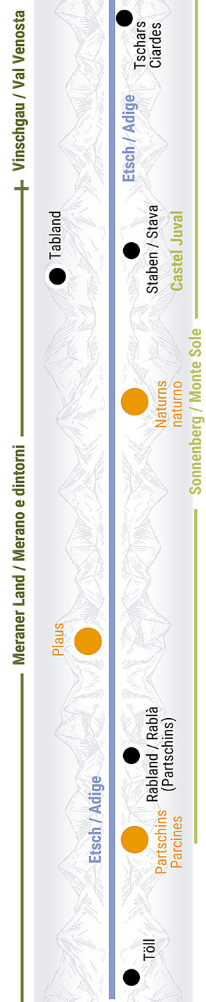
The cycling route crosses apple orchards and verdant meadows, following the Etsch river for long stretches as it leads you to Staben/Stava, Tschirland/Cirlano and Naturns/Naturno. The market town has one of the valley’s most lively centers, offering countless restaurants and shops. Although the cycling route follows the river, you have many opportunities to take a detour to the center. It offers some cultural and historical highlights: the St. Prokulus museum with its didactically well-prepared exhibits and the adjacent Prokuluskirchlein, a little church with spectacular frescoes, some of which date back to the 7th century. Continue along the Etsch river to Plaus and Rabland/Rablà, the site where one of the two historical milestones of the Via Claudia Augusta was discovered. The main district of the municipality of Partschins/Parcines is located a little way uphill from the route. The cycling route continues to the fault scarp at Töll/Tel, the geographical boundary of the Vinschgau valley and the site of a former toll station.

Rabland/Rablà, Partschins/Parcines, Töll/Tel (municipality of Partschins/Parcines)

Food and drink

Questions and information about the section

For information about the entire route, contact

Via Claudia Augusta Info
www.viaclaudia.org/en
info@viaclaudia.org
0043 664 27 63 555

For specific questions about the region, contact

www.suedtirol.info/en
info@suedtirol.info
0039 0471 999 999

Accommodation and camping

Radroute, Gastgeber, historische interaktive Karte mit Symbolen


Diesen interaktiven Bereich können Sie nutzen unter:
/en/road-biking/detailed-description-of-the-altinate-route

Do you have feedback or ideas for the cycling route? Let us know /


Diesen interaktiven Bereich können Sie nutzen unter:
/en/road-biking/detailed-description-of-the-altinate-route

jump back to the beginning of the detailed description of the Altinate cycling route / jump to northern Tyrol / jump to the Reschenpass / jump to Trento / jump to the whole history of the Via Claudia Augusta / jump to the history of the regions and towns along the Altinate route / jump to the ‘twenty-four maps through the centuries’ for each region along the Via Claudia Augusta / jump to the full spectrum of culture across the regions and towns (Altinate) / jump to the specialities of the regions and towns / jump to the wines of the regions and towns /


DRUCK
Panorama Algund Marling Foto Tschaikner
Brücke Algund
Marling Berge Äpfel
Ponte Algund
Radler Etschbrücke Algund
Radler Meran
Radweg Algund
Sessel Via Claudia Augusta Algund
Radweg Algund
Algund Panorama Sessellift
Algund Waalweg
Gartendorf Algund
Lauben Meran Foto Meranerland
Meran Merano Kurstadt
Schloss Tirol
Terme Merano

Cycling route to Algund/Lagundo, Meran/Merano and Marling/Marlengo

Radroute, historische interaktive Karte mit Symbolen

After passing the fault scarp of Töll/Tel, you enter one of the most spectacular sections of the Via Claudia Augusta cycling route. The garden village of Algund/Lagundo welcomes you with a pergola and oversized chairs from which you have a lovely view. A serpentine road takes you down into the village, where you get to enjoy a truly Mediterranean climate. In Algund/Lagundo and the nearby spa town of Meran/Merano, palm trees and other Mediterranean plants abound. Once you reach the bottom, explore the „Brückenkopf“ museum in Algund/Lagundo. It is dedicated to the remains of the Medieval bridge over the Etsch river that used to stand here. This is probably where the Romans crossed the river, too: it is the last possible section for a crossing before the river becomes as wide as the entire valley itself. Afterwards, you can either follow the cycle route to the edge of Meran/Merano and head to the center of the town to admire the famous covered alley or the spa house. Alternatively, cross the river on the wooden bridge in Algund/Lagundo and follow the old road to Marling/Marlengo.

The garden village of Algund/Lagundo at the old bridge over the Etsch river

The spa town of Meran/Merano

The panoramic village of Marling/Marlengo on the western slopes above Meran/Merano

Food and drink

Questions and information about the section

Accommodation and camping

Radroute, Gastgeber, historische interaktive Karte mit Symbolen

Excursion: the Brückenkopf museum, a symbol of an important road


Diesen interaktiven Bereich können Sie nutzen unter:
/en/road-biking/detailed-description-of-the-altinate-route

Do you have feedback or ideas for the cycling route? Let us know /


Diesen interaktiven Bereich können Sie nutzen unter:
/en/road-biking/detailed-description-of-the-altinate-route

jump back to the beginning of the detailed description of the Altinate cycling route / jump to northern Tyrol / jump to the Reschenpass / jump to Trento / jump to the whole history of the Via Claudia Augusta / jump to the history of the regions and towns along the Altinate route / jump to the ‘twenty-four maps through the centuries’ for each region along the Via Claudia Augusta / jump to the full spectrum of culture across the regions and towns (Altinate) / jump to the specialities of the regions and towns / jump to the wines of the regions and towns /


DRUCK
Eppan
Burg Lana
Terlan Pfarrkirche
Rad Lana

Cycling route through Tscherms/Cermes, Lana, Nals/Nalles, Andrian/Andriano, Bolzano/Bozen

Radroute, historische interaktive Karte mit Symbolen

To get from Marling/Marlengo to Bolzano/Bozen, either take the Etschtal cycle path, which runs across the bottom of the valley in a straight line, or cycle through the picturesque villages of Tscherms/Cermes, Oberlana/Lana di Sopra, Mitterlana/Lana di Mezzo, Niederlana/Lana di Sotto, Nals/Nalles and Andrian/Andriano. Each of them has plenty for you to discover. The parish church of Niederlana/Lana di Sotto and the South Tyrolean Museum of Fruit-Growing just around the corner are particularly worth seeing. Keep looking up as you cycle along the route, and you will spot castle upon castle.

Tscherms/Cermes, Lana, Burgstall/Postal, Gargazon/Gargazzone

The wine and rose village of Nals/Nalles and Andrian/Andriano

The old mining town and modern asparagus-growing area of Terlan/Terlano

Food and drink

Questions and information about the section

For information about the entire route, contact

Via Claudia Augusta Info
www.viaclaudia.org/en
info@viaclaudia.org
0043 664 27 63 555

For specific questions about the region, contact

www.suedtirol.info/en
info@suedtirol.info
0039 0471 999 999

Accommodation and camping

Radroute, Gastgeber, historische interaktive Karte mit Symbolen


Diesen interaktiven Bereich können Sie nutzen unter:
/en/road-biking/detailed-description-of-the-altinate-route

Do you have feedback or ideas for the cycling route? Let us know /


Diesen interaktiven Bereich können Sie nutzen unter:
/en/road-biking/detailed-description-of-the-altinate-route

jump back to the beginning of the detailed description of the Altinate cycling route / jump to northern Tyrol / jump to the Reschenpass / jump to Trento / jump to the whole history of the Via Claudia Augusta / jump to the history of the regions and towns along the Altinate route / jump to the ‘twenty-four maps through the centuries’ for each region along the Via Claudia Augusta / jump to the full spectrum of culture across the regions and towns (Altinate) / jump to the specialities of the regions and towns / jump to the wines of the regions and towns /


DRUCK
Radbrücke Bozen
Bozen Museion Fassade Brücke
Bozen Stimmung Abend Waltherplatz
Bozen Panoramaaufnahme
Meilenstein Foto
Bozen Laubengasse, Foto: Tourismusverein Bozen
Bozen Öthi Reconstruction Ochsenreiter
Bozen Funivia Del Renon, Rittner Seilbahn

Cycling route to and through Bolzano/Bozen (or across the Wine Road)

Radroute, historische interaktive Karte mit Symbolen

Once you reach Frangart/Frangarto, you are in Bolzano/Bozen. Siegmundskron castle thrones above the town. It houses the Messner Mountain Museum, a museum created by the famous mountaineer Reinhold Messner. You can either follow the Etschtal cycle path along the valley, perhaps take a little detour to the city center along the Eisack river, or cycle along the wine road through the villages of Eppan/Apiano and Kaltern am See/Caldaro. The center of Bolzano/Bozen is a melting pot of ancient history and vibrant modernity that blends the German and Italian lifestyles into a unique mixture. Along the Wine Road, which you reach on a former railway track, you can visit famous wine-growing villages and Kalterer See lake.

Taking the Drususallee/Viale Druso to the city center

A meander through town

Leaving central Bolzano/Bozen on the Drususbrücke bridge

Food and drink

Questions and information about the section

Accommodation and camping

Radroute, Gastgeber, historische interaktive Karte mit Symbolen


Diesen interaktiven Bereich können Sie nutzen unter:
/en/road-biking/detailed-description-of-the-altinate-route

Do you have feedback or ideas for the cycling route? Let us know /


Diesen interaktiven Bereich können Sie nutzen unter:
/en/road-biking/detailed-description-of-the-altinate-route

jump back to the beginning of the detailed description of the Altinate cycling route / jump to northern Tyrol / jump to the Reschenpass / jump to Trento / jump to the whole history of the Via Claudia Augusta / jump to the history of the regions and towns along the Altinate route / jump to the ‘twenty-four maps through the centuries’ for each region along the Via Claudia Augusta / jump to the full spectrum of culture across the regions and towns (Altinate) / jump to the specialities of the regions and towns / jump to the wines of the regions and towns /


DRUCK
Castelfeder
Radweg Kaltern
Kaltern Wein See
Neumarkt Lauben
Strassenstation Endidä
Salurner Klause

Cycling route through the South Tyrolean Unterland (in the Etschtal valley or via the Wine Road)

Radroute, historische interaktive Karte mit Symbolen

The cycling route follows the Etsch river to Vadena/Pfatten, leading you to the edge of the town of Laives/Leifers and onwards to Bronzolo/Branzoll. Between the two towns, the river used to serve the purpose of an alternative transportation route for heavy loads. Just before you reach Auer/Ora, you can cross from the route along the Etsch river to that along the Wine Road or vice versa. The Wine Road route will lead you through the pretty wine-growing villages of Tramin/Termeno, Kurtatsch/Cortaccia, Magreid/Magrè and Kurtinig/Cortina before taking you to Salorno/Salurn. The route along the river first leads to Auer/Ora. This quaint village is situated at the foot of the striking Castelfeder hill. Afterwards, you cycle through Neumarkt/Egna, where the Roman road station of Endidae used to stand. Laag/Laghetti, a district of Neumarkt/Egna, is probably named after a lake that was created by the drift of the Noce river and separated the valley into two parts. As you approach the gorge, you reach the picturesque town of Salorno/Salurn. Haderburg castle, which towers above the town, was built to protect the strategically significant spot that forms the boundary between the German-speaking and Italian-speaking parts of the region today.

Laives/Leifers, Bronzolo/Branzoll and Vadena/Pfatten

Auer/Ora and Castelfeder

Endidae, Neumarkt/Egna and Laag/Laghetti

Salorno/Salurn near the famous Salurner Klause

Eppan/Apiano on the Wine Road

Kaltern am See/Caldaro

Tramin/Termeno, Kurtatsch/Cortaccia, Magreid/Magrè and Kurtinig/Cortina

Food and drink

Questions and information about the section

For information about the entire route, contact

Via Claudia Augusta Info
www.viaclaudia.org/en
info@viaclaudia.org
0043 664 27 63 555

For specific questions about the region, contact

www.suedtirol.info/en
info@suedtirol.info
0039 0471 999 999

Accommodation and camping

Radroute, Gastgeber, historische interaktive Karte mit Symbolen


Diesen interaktiven Bereich können Sie nutzen unter:
/en/road-biking/detailed-description-of-the-altinate-route

Do you have feedback or ideas for the cycling route? Let us know /


Diesen interaktiven Bereich können Sie nutzen unter:
/en/road-biking/detailed-description-of-the-altinate-route

jump back to the beginning of the detailed description of the Altinate cycling route / jump to northern Tyrol / jump to the Reschenpass / jump to Trento / jump to the whole history of the Via Claudia Augusta / jump to the history of the regions and towns along the Altinate route / jump to the ‘twenty-four maps through the centuries’ for each region along the Via Claudia Augusta / jump to the full spectrum of culture across the regions and towns (Altinate) / jump to the specialities of the regions and towns / jump to the wines of the regions and towns /


DRUCK
Piana Rotalina von oben
Castello Corona
Mezzolombardo historisches Zentrum aus der Luft
San Michele
Lavis Giardino Dei Ciucioi

Cycling route across the Piana Rotaliana

Radroute, historische interaktive Karte mit Symbolen

If you simply follow the Etschtal cycle path rather than the route through the Piana Rotaliana, you will miss out on quite a few sights. The plain where the Noce flows into the Etsch river is covered nearly entirely in Teroldego grapevines, a variety of grape that originates here. First, the cycling route takes you to Roverè della Luna and Mezzocorona, the agricultural center of the plain, overlooked by the St. Gotthard castle, which was built into a crevice of the rock. A cable car takes you to the Monte plateau on the summit, offering spectacular views of the plain. Mezzolombardo, the next stop on the route, is the commercial center of the region. Traditionally, San Michele used to be its cultural counterpart on account of its monastery. Today, the former monastery houses the agricultural center of Trentino and an interesting museum of local folklore. In the southern part of the Piana Rotaliana lies the former river port of Nave San Rocco, the asparagus-growing town of Zambana, and the town of Lavis, whose beautiful center and hanging gardens make for a lovely walk.

Crossing the linguistic boundary to Roveré della Luna

Mezzocorona, the current agricultural center

Mezzolombardo, the commercial center of the Nonstal valley

San Michele all‘Adige. Center of agricultural competence

Faedo, Nave San Roco and Zambana

Lavis at the entrance of the Avisio valley

Food and drink

Questions and information about the section

Accommodation and camping

Radroute, Gastgeber, historische interaktive Karte mit Symbolen

Excursion: Cittadella del Vino Rotary – the center of the Teroldego


Diesen interaktiven Bereich können Sie nutzen unter:
/en/road-biking/detailed-description-of-the-altinate-route

Do you have feedback or ideas for the cycling route? Let us know /


Diesen interaktiven Bereich können Sie nutzen unter:
/en/road-biking/detailed-description-of-the-altinate-route

jump back to the beginning of the detailed description of the Altinate cycling route / jump to northern Tyrol / jump to the Reschenpass / jump to Trento / jump to the whole history of the Via Claudia Augusta / jump to the history of the regions and towns along the Altinate route / jump to the ‘twenty-four maps through the centuries’ for each region along the Via Claudia Augusta / jump to the full spectrum of culture across the regions and towns (Altinate) / jump to the specialities of the regions and towns / jump to the wines of the regions and towns /


DRUCK
Rad Frühling Val Di Cembra
Val Di Cembra da San Floriano
Val Di Cembra, Cembra e Faver Visti da Sevignano
Panorama Verla Di Giovo
Piramidi Di Segonzano
Albiano Porphyry Quarry
DRUCK

Diesen interaktiven Bereich können Sie nutzen unter:
/en/road-biking/detailed-description-of-the-altinate-route

Do you have feedback or ideas for the cycling route? Let us know /


Diesen interaktiven Bereich können Sie nutzen unter:
/en/road-biking/detailed-description-of-the-altinate-route

jump back to the beginning of the detailed description of the Altinate cycling route / jump to northern Tyrol / jump to the Reschenpass / jump to Trento / jump to the whole history of the Via Claudia Augusta / jump to the history of the regions and towns along the Altinate route / jump to the ‘twenty-four maps through the centuries’ for each region along the Via Claudia Augusta / jump to the full spectrum of culture across the regions and towns (Altinate) / jump to the specialities of the regions and towns / jump to the wines of the regions and towns /


DRUCK
Trento
Paganella Brenta Trento, Foto: Gemeinfrei Wikipedia
Trento
Unterirdisches Tridentum Zotta
Buonconsiglio, Foto: Jakub Halun
Loggia Del Buonconsiglio
Palazzo Pretorio di Trento
Trento Campanile, Foto: Wikipedia Markus Bernet
Muse
Trento, Fest, Domplatz

Cycling route through Trento to the Valsugana

Radroute, historische interaktive Karte mit Symbolen

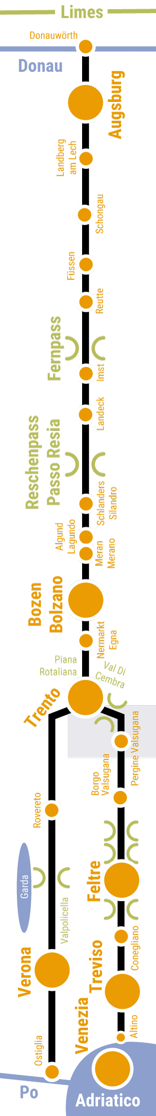
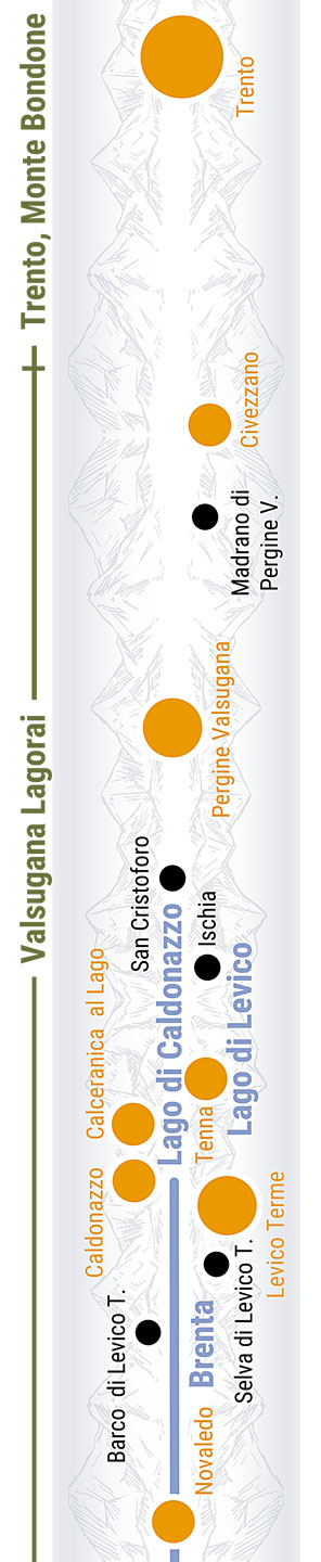
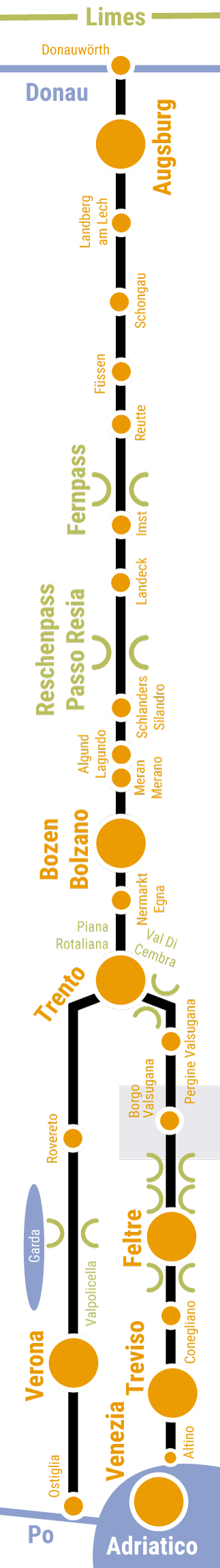
The Avisio river forms the boundary between Lavis and the northern parts of Trento, the capital of Trentino. The cycling route runs to Lavis at the edge of the village, where it crosses the river. You return to the banks of the Etsch river once again and cycle to the center of Trento at a leisurely pace. Founded during Roman times, it is the birthplace of the Counter-Reformation. The old town was spruced up impressively in the Renaissance style for the Council of Trent. Buonconsiglio castle also reflects the monumental event. Underneath the city, you can visit excavations of the ancient Roman city of Tridentum. The cycling route towards Altino takes you to the north of the city again, where you will climb the ascent between the Etschtal valley and Valsugana, following the track of the old Roman road. You are treated to lovely views of the city behind you. Along the way, you will pass the Ecomuseo Argentario, which documents the silver mining past of the region. Once you reach the Valsugana, the route takes you past a fortress from the First World War and through pretty villages and stunning natural landscapes. In Pergine, you cycle along the Via Maier road, which dates back to the Renaissance. The cycling route continues along the foot of the Castello di Pergine and above Levicosee lake  as you head towards Levico Terme, a spa and garrison town founded by the Habsburgs.

The route to the old town

Trento, the Roman city of Tridentum

Following the Altinate into the Valsugana

Following the Padana into the Vallagarina

Food and drink

Questions and information about the section

Accommodation and camping

Radroute, Gastgeber, historische interaktive Karte mit Symbolen


Diesen interaktiven Bereich können Sie nutzen unter:
/en/road-biking/detailed-description-of-the-altinate-route

Do you have feedback or ideas for the cycling route? Let us know /


Diesen interaktiven Bereich können Sie nutzen unter:
/en/road-biking/detailed-description-of-the-altinate-route

jump to the detailed description of the cycling route (Padana) /


Diesen interaktiven Bereich können Sie nutzen unter:
/en/road-biking/detailed-description-of-the-altinate-route

jump back to the beginning of the detailed description of the Altinate cycling route / jump to northern Tyrol / jump to the Reschenpass / jump to Trento / jump to the whole history of the Via Claudia Augusta / jump to the history of the regions and towns along the Altinate route / jump to the ‘twenty-four maps through the centuries’ for each region along the Via Claudia Augusta / jump to the full spectrum of culture across the regions and towns (Altinate) / jump to the specialities of the regions and towns / jump to the wines of the regions and towns /


DRUCK
Alta Valsugana, Laghi Seen
Gran Hotel Levico, Terme, Alta Valsugana, Trentino
Castell Pergine, Alta Valsugana
Bici Lago Di Levico Alta Valsugana

Cycling route through cycling route Civezzano, Pergine Valsugana, Levico Terme

Radroute, historische interaktive Karte mit Symbolen

The cycling route takes you from Trento through the Ecomuseo Argentario, which documents the silver mining past of the region, before continuing to Civezzano. The Civezzano fortress from the First World War guards the entrance to the Valsugana. You cycle through pretty villages and picturesque landscapes. In Pergine, you follow the Via Maier road, which dates back to the Renaissance. The cycling route then continues along the foot of the Castello di Pergine and above Levicosee lake  as you head towards Levico Terme, a spa town founded by the Habsburgs.

The Habsburg spa town of Levico Terme

Food and drink

Questions and information about the section

For information about the entire route, contact the

Via Claudia Augusta Info
www.viaclaudia.org/en
info@viaclaudia.org
0043 664 27 63 555

For specific questions about the region, contact the

tourist information office of the APT Valsugana Lagorai
www.visitvalsugana.it/en
38057 Pergine Valsugana, Piazza Serra, 10
38056 Levico Terme, Viale Vittorio Emanuele III, 3
38051 Borgo Valsugana, Piazza De Gasperi
38053 Castello Tesino, Via Dante, 10
info@visitvalsugana.it
0039 0461 727 700

Accommodation and camping

Radroute, Gastgeber, historische interaktive Karte mit Symbolen


Diesen interaktiven Bereich können Sie nutzen unter:
/en/road-biking/detailed-description-of-the-altinate-route

Do you have feedback or ideas for the cycling route? Let us know /


Diesen interaktiven Bereich können Sie nutzen unter:
/en/road-biking/detailed-description-of-the-altinate-route

jump to the detailed description of the cycling route (Padana) /


Diesen interaktiven Bereich können Sie nutzen unter:
/en/road-biking/detailed-description-of-the-altinate-route

jump back to the beginning of the detailed description of the Altinate cycling route / jump to northern Tyrol / jump to the Reschenpass / jump to Trento / jump to the whole history of the Via Claudia Augusta / jump to the history of the regions and towns along the Altinate route / jump to the ‘twenty-four maps through the centuries’ for each region along the Via Claudia Augusta / jump to the full spectrum of culture across the regions and towns (Altinate) / jump to the specialities of the regions and towns / jump to the wines of the regions and towns /


DRUCK
Borgo Flair Di Venezia Media Valsugana Trentino
Castello Telvana Media Valsugana Borgo Trentino
Bici Valsugana Trentino

Cycling route through the middle Vallagarina

Radroute, historische interaktive Karte mit Symbolen

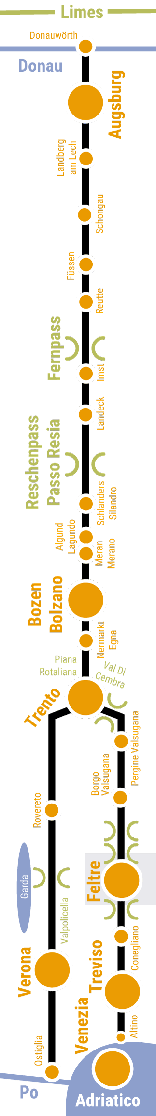
From Levico, the cycling route takes you to the picturesque district of Selva and continues along the bottom of the valley. It follows the Brenta cycling route until Marter before leading you through the second spa town of the Valsugana: Roncegno Terme. From here, you cycle across verdant meadows to Borgo, with the Castel Telvana providing a splendid backdrop. Borgo is the main district of the Media and Bassa Valsugana. The road through the historical town center corresponds to the Via Claudia Augusta. After you leave Borgo, you continue to Castelnuovo, where you can take in lovely views of Ivano castle. Gradually climb from the bottom of the valley to the Tesino high plateau. Do not forget to look back and soak up the wonderful views over the valley.

Heading to Borgo via Novaledo and Roncegno Terme

Borgo Valsugana

From Borgo to Strigno

Food and drink

Questions and information about the section

For information about the entire route, contact the

Via Claudia Augusta Info
www.viaclaudia.org/en
info@viaclaudia.org
0043 664 27 63 555

For specific questions about the region, contact the

tourist information office of the APT Valsugana Lagorai
www.visitvalsugana.it/en
38057 Pergine Valsugana, Piazza Serra, 10
38056 Levico Terme, Viale Vittorio Emanuele III, 3
38051 Borgo Valsugana, Piazza De Gasperi
38053 Castello Tesino, Via Dante, 10
info@visitvalsugana.it
0039 0461 727 700

Accommodation and camping

Radroute, Gastgeber, historische interaktive Karte mit Symbolen


Diesen interaktiven Bereich können Sie nutzen unter:
/en/road-biking/detailed-description-of-the-altinate-route

Do you have feedback or ideas for the cycling route? Let us know /


Diesen interaktiven Bereich können Sie nutzen unter:
/en/road-biking/detailed-description-of-the-altinate-route

jump to the detailed description of the cycling route (Padana) /


Diesen interaktiven Bereich können Sie nutzen unter:
/en/road-biking/detailed-description-of-the-altinate-route

jump back to the beginning of the detailed description of the Altinate cycling route / jump to northern Tyrol / jump to the Reschenpass / jump to Trento / jump to the whole history of the Via Claudia Augusta / jump to the history of the regions and towns along the Altinate route / jump to the ‘twenty-four maps through the centuries’ for each region along the Via Claudia Augusta / jump to the full spectrum of culture across the regions and towns (Altinate) / jump to the specialities of the regions and towns / jump to the wines of the regions and towns /


DRUCK
Bici Tesino Trentino
Vor den Dolomiten Parcon Nazionale Dolomiti
Castello Tesino Via Claudia Augusta
Lamon Chiesa Kirche San Pietro
Lamon Montagna Berge Dolomiti

Cycling route across the Tesino plateau to Lamon, Sovramonte and Croce D'Aune

Radroute, historische interaktive Karte mit Symbolen

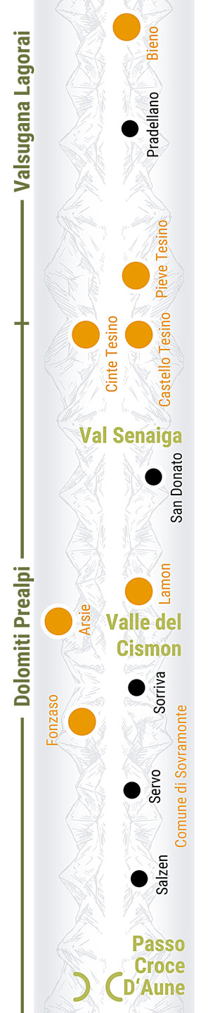
Once you reach Bieno, you have mastered the hardest part of the ascent. This makes the town feel like a part of the Tesino high plateau. Running through an idyllic landscape, the cycling route crosses a wild stream and takes you past a lake into the picturesque town of Pieve Tesino, which it traverses in its entirety. It is said that the hill above Castello Tesino used to be the site of a Roman fortress. Continue along beautiful mountain roads to Lamon. The Roman road used to cross the gorge of the Senaiga stream on the other side of the valley before traversing the picture-perfect town of San Donato, where a Roman cemetery remains as testimony to an ancient settlement. If you do not mind gravel paths, take this route and be rewarded with stunning nature and fascinating historical insights. Lamon and the next town of Sovramonte are located on the edge of the Dolomiti Bellunesi National Park. Cycle through a ravine just before Sovramonte, then continue steadily towards the Passo Croce D’Aune. A bicycle shuttle is available to take you up to the Tesino High Valley and from Ponte Oltra to the Croce D’Aune Pass. You can book it by text message.

To Lamon and Sovramonte in Veneto

Food and drink

Questions and information about the section

For information about the entire route, contact the

Via Claudia Augusta Info
www.viaclaudia.org/en
info@viaclaudia.org
0043 664 27 63 555

For specific questions about the region up to Castello Tesino, contact

the tourist information office of the APT Valsugana Lagorai
www.visitvalsugana.it/en
38057 Pergine Valsugana, Piazza Serra, 10
38056 Levico Terme, Viale Vittorio Emanuele III, 3
38051 Borgo Valsugana, Piazza De Gasperi
38053 Castello Tesino, Via Dante, 10

info@visitvalsugana.it
0039 0461 727 700

For specific questions about the region from San Donato (municipality of Lamon) onwards, contact

the tourist information office of the Consorzio Turistico Dolomiti Prealpi
www.dolomitiprealpi.it/en
32032 Feltre, Piazza Vittorio Emanuele II, 21
32026 Mel, Piazza Papa Luciani
info@dolomitiprealpi
0039 329 272 900

Accommodation and camping

Radroute, Gastgeber, historische interaktive Karte mit Symbolen


Diesen interaktiven Bereich können Sie nutzen unter:
/en/road-biking/detailed-description-of-the-altinate-route

Do you have feedback or ideas for the cycling route? Let us know /


Diesen interaktiven Bereich können Sie nutzen unter:
/en/road-biking/detailed-description-of-the-altinate-route

jump to the detailed description of the cycling route (Padana) /


Diesen interaktiven Bereich können Sie nutzen unter:
/en/road-biking/detailed-description-of-the-altinate-route

jump back to the beginning of the detailed description of the Altinate cycling route / jump to northern Tyrol / jump to the Reschenpass / jump to Trento / jump to the whole history of the Via Claudia Augusta / jump to the history of the regions and towns along the Altinate route / jump to the ‘twenty-four maps through the centuries’ for each region along the Via Claudia Augusta / jump to the full spectrum of culture across the regions and towns (Altinate) / jump to the specialities of the regions and towns / jump to the wines of the regions and towns /


DRUCK
Feltre vor den Alpen
Fabbrica Pedavena Museo Birra Bier Museum
Feltre Area Archeologica Citta Romana
Feltre Piazza Maggiore Rad Bici
Meilenstein Pietra Miliare Cesiomaggiore

Cycling route through Feltre and Feltrino

Radroute, historische interaktive Karte mit Symbolen

Descend from the Croce D‘Aune Pass towards Feltre along a winding road. You will reach the historic city through Pedavena, which beckons you to take a rest and have a beer at Italy’s largest Birreria. The cycling route takes you through the pedestrian shopping area of Feltre, along the town’s medieval city walls. You can access the historical center by taking the steps or the lift, which departs in a tunnel underneath the city. Having left Feltre, you will cycle through a picturesque boulevard with magnificent views of the Alpine foothills, past the splendid Ville Venete and through quaint villages to reach Cesiomaggiore. This town is the discovery site of one of the two historical milestones that document the construction of the Via Claudia Augusta. The Roman road crossed the river between Santa Giustina and Mel. The cycling route, on the other hand, crosses it between Busche and Cesana: another historical river crossing that functions as a dam for the wild stream today. Downhill from the reservoir lies a popular beach with a café.

A walk through historical Feltre

Food and drink

Questions and information about the section

For information, contact

Via Claudia Augusta Info
www.viaclaudia.org/en
info@viaclaudia.org
0043 664 27 63 555

For specific questions about the region, contact

the tourist information office of the Consorzio Turistico Dolomiti Prealpi
www.dolomitiprealpi.it/en
32032 Feltre, Piazza Vittorio Emanuele II, 21
32026 Mel, Piazza Papa Luciani
info@dolomitiprealpi
0039 329 272 900

Accommodation and camping

Radroute, Gastgeber, historische interaktive Karte mit Symbolen


Diesen interaktiven Bereich können Sie nutzen unter:
/en/road-biking/detailed-description-of-the-altinate-route

The difference between chestnuts and sweet chestnuts / Feltrino, a part of the Rhaetian cultural sphere /


Diesen interaktiven Bereich können Sie nutzen unter:
/en/road-biking/detailed-description-of-the-altinate-route

Do you have feedback or ideas for the cycling route? Let us know /


Diesen interaktiven Bereich können Sie nutzen unter:
/en/road-biking/detailed-description-of-the-altinate-route

jump to the detailed description of the cycling route (Padana) /


Diesen interaktiven Bereich können Sie nutzen unter:
/en/road-biking/detailed-description-of-the-altinate-route

jump back to the beginning of the detailed description of the Altinate cycling route / jump to northern Tyrol / jump to the Reschenpass / jump to Trento / jump to the whole history of the Via Claudia Augusta / jump to the history of the regions and towns along the Altinate route / jump to the ‘twenty-four maps through the centuries’ for each region along the Via Claudia Augusta / jump to the full spectrum of culture across the regions and towns (Altinate) / jump to the specialities of the regions and towns / jump to the wines of the regions and towns /


DRUCK
Piave Regenstimmung Pieno Di Acqua
Mel Beate
interno chiesa 2014
madonna latte 2018
piave lentiai sudiero
Chiesa Lentiai
Castello Di Zumelle
Piave Mel
Collina Mel
Case Mel
Palazzo Municipale Mel
Piazza Mel
Chiesa Mel
Visita Guidata Führung Museo

Cycling route through Piave Cesana, Lentiai, Bardies and Mel

Radroute, historische interaktive Karte mit Symbolen

Back in the day, the old Roman road crossed the Piave river on a ford between Santa Giustina and the Nave district of the municipality of Borgo Valbelluna. Its name, ‘Nave’, is a clear indicator. Another Roman crossing probably used to exist where the cycling route crosses the river today, between Busche and Cesana. After you cross the river, you will need to make a decision: either tackle the picturesque Praderadego pass on your own, take a shuttle across the pass (book by text message, www.viaclaudia.org), or leave the Romans’ tracks briefly to follow the river and cycle along a relatively busy road towards Valdobbiadene. You can continue to the southern side of the pass from there. The view from the Praderadego over the Prosecco Hills is well worth it. In clear conditions, you can see all the way to the Venetian Lagoon. The route through the Valbelluna towards Praderadego leads you to Lentiai through several villages. In Bardies, the road starts its ascent towards the pass. From Corte, you can take a detour to the main district of Mel, where the shuttle to the pass departs from the piazza (alternatively, embark in Bardies).

The town of Mel

Lentiai, Castello Zumelle and St. Vittore and Corona

Food and drink

Questions and information about the section

For information, contact

Via Claudia Augusta Info
www.viaclaudia.org/en
info@viaclaudia.org
0043 664 27 63 555

For specific questions about the region, contact the

tourist information office of the Consorzio Turistico Dolomiti Prealpi
www.dolomitiprealpi.it/en
32032 Feltre, Piazza Vittorio Emanuele II, 21
32026 Mel, Piazza Papa Luciani
info@dolomitiprealpi
0039 329 272 900

Accommodation and camping

Radroute, Gastgeber, historische interaktive Karte mit Symbolen


Diesen interaktiven Bereich können Sie nutzen unter:
/en/road-biking/detailed-description-of-the-altinate-route

Another pass? /


Diesen interaktiven Bereich können Sie nutzen unter:
/en/road-biking/detailed-description-of-the-altinate-route

Do you have feedback or ideas for the cycling route? Let us know /


Diesen interaktiven Bereich können Sie nutzen unter:
/en/road-biking/detailed-description-of-the-altinate-route

jump to the detailed description of the cycling route (Padana) /


Diesen interaktiven Bereich können Sie nutzen unter:
/en/road-biking/detailed-description-of-the-altinate-route

jump back to the beginning of the detailed description of the Altinate cycling route / jump to northern Tyrol / jump to the Reschenpass / jump to Trento / jump to the whole history of the Via Claudia Augusta / jump to the history of the regions and towns along the Altinate route / jump to the ‘twenty-four maps through the centuries’ for each region along the Via Claudia Augusta / jump to the full spectrum of culture across the regions and towns (Altinate) / jump to the specialities of the regions and towns / jump to the wines of the regions and towns /


DRUCK
Praderadego Gruppe
Zumelle Nebbia Dalla Collina
castello di zumelle
Valle Zumelle
Praderadego Heu
Praderadego alle
Albergo Praderadego
Blick vom Praderadego
Felswand weit
Felswand nah
Serpentinen Praderadego Radroute Wanderroute
Valmareno Castelbrando breit
Valmarino Castelbrando Alta Marca
Landscape
Proseccodorf
Proseccodorf
Proseccodorf nah
Prosecco Weinstraße Veneto Altamarca
Landscape
Proseccostraße Abendstimmung
Kellereiführung
Bici Castelbrando Valmarino Veneto Alta Marca
Bike Tours Prosecco Bell Asolo

Cycling route across the Praderadego pass to AltaMarca, the home of prosecco

Radroute, historische interaktive Karte mit Symbolen

From Bardies, the route starts its ascent towards Praderadego. The road leads you past picturesque villages and the Castello di Zumelle. On the idyllic peak of the pass, a mountain inn and a simple guesthouse await weary travelers. Head a little further and you will be treated to a spectacular view of the Prosecco Hills and the Venetian plain. In good conditions, you can even see the lagoon. Continue down a serpentine road into the Valmareno. Take in the magnificent views of the Renaissance castle of Castelbrando, which is worth a little detour. The cycling route now takes you through the villages of Follina (with a very interesting abbey) and Pieve di Soligo. Cycle past the Castello Collalto to cross the Prosecco Hills before you reach Susegana and Santa Lucia di Piave. As the name suggests, the district of Ponte della Priula, which belongs to Susegana, is home to one of only few bridges across the Piave river. Here, the cycling route switches to the right riverbank. You will see a little of each side of the river, according to the theories of historians who believe that the Roman road Via Claudia Augusta also switched between the two sides.

The Wine Road from Montello to Colli Asolani

Food and drink

Questions and information about the section

For information about the entire route, contact the

Via Claudia Augusta Info
www.viaclaudia.org/en
info@viaclaudia.org
0043 664 27 63 555

For specific questions about the region up to Praderadego/Quero-Vas,  contact

the tourist information office of the Consorzio Turistico Dolomiti Prealpi
www.dolomitiprealpi.it/en
32032 Feltre, Piazza Vittorio Emanuele II, 21
32026 Mel, Piazza Papa Luciani
info@dolomitiprealpi
0039 329 272 900

For specific questions about the region from Praderadego/Valdobbiadene onwards, contact

the Consorzio Turistico Marca Treviso
www.marcatreviso.it
info@marcatreviso.it
0039 0422 595 790

Accommodation and camping

Radroute, Gastgeber, historische interaktive Karte mit Symbolen


Diesen interaktiven Bereich können Sie nutzen unter:
/en/road-biking/detailed-description-of-the-altinate-route

Do you have feedback or ideas for the cycling route? Let us know /


Diesen interaktiven Bereich können Sie nutzen unter:
/en/road-biking/detailed-description-of-the-altinate-route

jump to the detailed description of the cycling route (Padana) /


Diesen interaktiven Bereich können Sie nutzen unter:
/en/road-biking/detailed-description-of-the-altinate-route

jump back to the beginning of the detailed description of the Altinate cycling route / jump to northern Tyrol / jump to the Reschenpass / jump to Trento / jump to the whole history of the Via Claudia Augusta / jump to the history of the regions and towns along the Altinate route / jump to the ‘twenty-four maps through the centuries’ for each region along the Via Claudia Augusta / jump to the full spectrum of culture across the regions and towns (Altinate) / jump to the specialities of the regions and towns / jump to the wines of the regions and towns /


DRUCK
Montello Villa Contarini Degli Armeni Veneto
Destra Piave, Geschichte, Kunst, Kultur, Grün
Nervesa Abbazia San Eustacchio Veneto Marca Treviso
Destra Piave, Geschichte, Kunst, Kultur
Destra Piave, Geschichte, Kunst, Kultur, Aussicht
Destra Piave, Geschichte, Kunst, Kultur
Destra Piave, Geschichte, Kunst, Kultur, Fluss
Spresiano Grave Del Piave
Destra Piave, Geschichte, Kunst, Kultur, Foto Fluss
Spresiano Chiesa Di Spresiano E Monumento Ai Caduti
Destra Piave, Geschichte, Kunst, Kultur, Wasser
Villa Veneta Villorba Veneto
Radler Vater Mit Kindern

Cycling route on the right bank of the River Piave

Radroute, historische interaktive Karte mit Symbolen

After you cross the wide riverbed of the Piave, the cycling route reveals the many facets of the Venetian Plain: nature, expansive agricultural fields, sleepy settlements and lively towns make up the area surrounding Treviso. Before you head south, consider visiting Nervesa della Battaglia. Its name and the ruins of the Saint Eustace Abbey are memorials to an especially fierce battle of the First World War. In the north of the municipality, you will find the wine-growing and local recreation area of Montello e Colli Asolani. After Spresiano, the cycling route leads you back to the Piave once more. In Palazzon, you will see the remnants of a medieval river port. Continue to Treviso, passing through Lovandina and Villorba on the way. Villorba is home to particularly many Ville Venete, which are typical of the region. One of them is used representatively by the municipal administration.

Spresiano

Villorba

Food and drink

Questions and information about the section

For information about the entire route, contact the

Via Claudia Augusta Info
www.viaclaudia.org/en
info@viaclaudia.org
0043 664 27 63 555

For specific questions about the region, contact the

Consorzio Turistico Marca Treviso
www.marcatreviso.it
info@marcatreviso.it
0039 0422 595 790

Accommodation and camping

Radroute, Gastgeber, historische interaktive Karte mit Symbolen


Diesen interaktiven Bereich können Sie nutzen unter:
/en/road-biking/detailed-description-of-the-altinate-route

Do you have feedback or ideas for the cycling route? Let us know /


Diesen interaktiven Bereich können Sie nutzen unter:
/en/road-biking/detailed-description-of-the-altinate-route

jump to the detailed description of the cycling route (Padana) /


Diesen interaktiven Bereich können Sie nutzen unter:
/en/road-biking/detailed-description-of-the-altinate-route

jump back to the beginning of the detailed description of the Altinate cycling route / jump to northern Tyrol / jump to the Reschenpass / jump to Trento / jump to the whole history of the Via Claudia Augusta / jump to the history of the regions and towns along the Altinate route / jump to the ‘twenty-four maps through the centuries’ for each region along the Via Claudia Augusta / jump to the full spectrum of culture across the regions and towns (Altinate) / jump to the specialities of the regions and towns / jump to the wines of the regions and towns /


DRUCK
Trevsio Citta Bici
Mura Treviso
Trevios Il Castello Romano Veneto Marca
Treviso I Buranelli By Night
Piazza dei Signori e Palazzo dei Trecento
Chiostro Seminario Vescovile Treviso
Treviso La Fontane Delle Tette

Cycling route through the City of Treviso

Radroute, historische interaktive Karte mit Symbolen

Coming from Villorba, the cycling route approaches the Porta San Tomaso – one of many gates leading to the old town – in a straight line. The old town is guarded by a towering wall overlooking lawns and a canal. The cycling route runs around the old town counter-clockwise. Afterwards, it follows the River Sile towards the Sile Natural Park.

A walk through the old town

Food and drink

Questions and information about the section

For information about the entire route, contact the

Via Claudia Augusta Info
www.viaclaudia.org/en
info@viaclaudia.org
0043 664 27 63 555

For specific questions about the region, contact the

Consorzio Turistico Marca Treviso
www.marcatreviso.it
info@marcatreviso.it
0039 0422 595 790

Accommodation and camping

Radroute, Gastgeber, historische interaktive Karte mit Symbolen


Diesen interaktiven Bereich können Sie nutzen unter:
/en/road-biking/detailed-description-of-the-altinate-route

Do you have feedback or ideas for the cycling route? Let us know /


Diesen interaktiven Bereich können Sie nutzen unter:
/en/road-biking/detailed-description-of-the-altinate-route

jump to the detailed description of the cycling route (Padana) /


Diesen interaktiven Bereich können Sie nutzen unter:
/en/road-biking/detailed-description-of-the-altinate-route

jump back to the beginning of the detailed description of the Altinate cycling route / jump to northern Tyrol / jump to the Reschenpass / jump to Trento / jump to the whole history of the Via Claudia Augusta / jump to the history of the regions and towns along the Altinate route / jump to the ‘twenty-four maps through the centuries’ for each region along the Via Claudia Augusta / jump to the full spectrum of culture across the regions and towns (Altinate) / jump to the specialities of the regions and towns / jump to the wines of the regions and towns /


DRUCK
Radler Paar Sile
Natufluss Park Sile Marca Treviso Veneto
Stadt Roncade Blick von oben
Castello Di Roncade

Cycling route along the River Sile through Silea and Roncade

Radroute, historische interaktive Karte mit Symbolen

As you head towards Quarto D‘Altino, the cycling route initially follows the Sile cycle path through the Sile Nature Park in the village of Silea. It crosses the river in Cendron and continues along the perfectly straight route of the Via Claudia Augusta through the municipal territory of Roncade. Take a detour to the center to visit the Castello di Roncade, then continue through the picturesque town of Musestre and cross the Sile to the piazza of Quarto D‘Altino.

The Sile River Regional Park and Silea

Roncade and the Castello di Roncade

Food and drink

Questions and information about the section

For information about the entire route, contact the

Via Claudia Augusta Info
www.viaclaudia.org/en
info@viaclaudia.org
0043 664 27 63 555

For specific questions about the region, contact the

Consorzio Turistico Marca Treviso
www.marcatreviso.it
info@marcatreviso.it
0039 0422 595 790

Accommodation and camping

Radroute, Gastgeber, historische interaktive Karte mit Symbolen


Diesen interaktiven Bereich können Sie nutzen unter:
/en/road-biking/detailed-description-of-the-altinate-route

Do you have feedback or ideas for the cycling route? Let us know /


Diesen interaktiven Bereich können Sie nutzen unter:
/en/road-biking/detailed-description-of-the-altinate-route

jump to the detailed description of the cycling route (Padana) /


Diesen interaktiven Bereich können Sie nutzen unter:
/en/road-biking/detailed-description-of-the-altinate-route

jump back to the beginning of the detailed description of the Altinate cycling route / jump to northern Tyrol / jump to the Reschenpass / jump to Trento / jump to the whole history of the Via Claudia Augusta / jump to the history of the regions and towns along the Altinate route / jump to the ‘twenty-four maps through the centuries’ for each region along the Via Claudia Augusta / jump to the full spectrum of culture across the regions and towns (Altinate) / jump to the specialities of the regions and towns / jump to the wines of the regions and towns /


DRUCK
Radstaffel zwischen Quarto und Altino
Altino Strada Romana Römerstraße
Vecchio Altes Museo
Laguna Di Venezia
Karte Venedig Lagune
Venice Lagoon December
Venice Old Town Lagoon
Bacino di San Marco in Venice
Piazza San Marco
La Fenice Opera House

Cycling route to Altino (or Venice and Jesolo)

Radroute, historische interaktive Karte mit Symbolen

Both the Roman road and the Via Claudia Augusta cycling route run from Quarto D‘Altino to Altino, the site of an ancient Adriatic port at the edge of the lagoon. It offers an interesting archaeological museum with a three-dimensional model of the port town. If you want to spend a few days relaxing after your big cycling tour, we recommend that you stay in Quarto d’Altino: it is quieter and more reasonably priced. You can take a train or a barca (boat) to Venice from there. Of course, you can also cycle to Trevio or to the Lido di Jesolo.

The ancient port on the lagoon

Food and drink

Questions and information about the section

For information about the entire route, contact the

Via Claudia Augusta Info
www.viaclaudia.org/en
info@viaclaudia.org
0043 664 27 63 555

For specific questions about the region, contact the

Consorzio Turistico Marca Treviso
www.marcatreviso.it
info@marcatreviso.it
0039 0422 595 790

Accommodation and camping

Radroute, Gastgeber, historische interaktive Karte mit Symbolen


Diesen interaktiven Bereich können Sie nutzen unter:
/en/road-biking/detailed-description-of-the-altinate-route

Do you have feedback or ideas for the cycling route? Let us know /


Diesen interaktiven Bereich können Sie nutzen unter:
/en/road-biking/detailed-description-of-the-altinate-route

jump to the detailed description of the cycling route (Padana) /


Diesen interaktiven Bereich können Sie nutzen unter:
/en/road-biking/detailed-description-of-the-altinate-route

jump back to the beginning of the detailed description of the Altinate cycling route / jump to northern Tyrol / jump to the Reschenpass / jump to Trento / jump to the whole history of the Via Claudia Augusta / jump to the history of the regions and towns along the Altinate route / jump to the ‘twenty-four maps through the centuries’ for each region along the Via Claudia Augusta / jump to the full spectrum of culture across the regions and towns (Altinate) / jump to the specialities of the regions and towns / jump to the wines of the regions and towns /


Via Claudia Augusta / +43 664 27 63 555 / info@viaclaudia.org